

B24 - Tour della Grecìa Salentina
A cycling route starting in Calimera, Apulia, Italy.
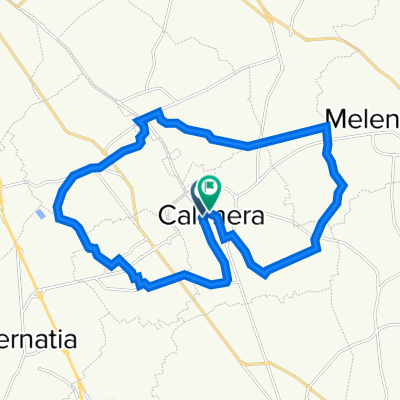
Overview
About this route
The route unfolds through the local roads of the Grecìa Salentina territory, among olive groves and dry stone walls, and touches all the centers of the Hellenophone area. Each municipality is crossed through the characteristic streets of the historic center.
- -:--
- Duration
- 43.8 km
- Distance
- 97 m
- Ascent
- 71 m
- Descent
- ---
- Avg. speed
- 103 m
- Max. altitude

Route quality
Waytypes & surfaces along the route
Waytypes
Quiet road
35.9 km
(82 %)
Road
6.1 km
(14 %)
Surfaces
Paved
15.8 km
(36 %)
Asphalt
15.8 km
(36 %)
Undefined
28 km
(64 %)
Route highlights
Points of interest along the route

Point of interest after 0.6 km
Il Mulino

Point of interest after 1.9 km
Percorso tra Calimera e Martano

Point of interest after 2.4 km
La Mandra (pineta comunale e percorso salute)

Accommodation after 3.9 km
Masseria Malopra (agriturismo)

Point of interest after 4.8 km
Naruralis Bio Resort

Point of interest after 5.9 km
Frantoio Ipogeo

Point of interest after 6.1 km
Case a corte

Point of interest after 7.3 km
Martano - Il Castello

Point of interest after 9.4 km
Masseria fortificata "Sciusciu"

Point of interest after 9.5 km
Antica via Traiana-Calabra

Point of interest after 11 km
Carpignano Salentino - Cripta Bizantina SS. Marina e Cristina

Point of interest after 16.7 km
Castrignano dei Greci - La piazza

Point of interest after 16.7 km
Chiesa madre (campanile)

Point of interest after 16.8 km
Il castello

Point of interest after 17 km
Cripta di Sant'Onofrio

Point of interest after 18.5 km
Melpignano - Piazza San Giorgio

Point of interest after 18.6 km
Palazzo marchesale

Point of interest after 19 km
Chiesa ed ex convento degli Agostiniani

Point of interest after 22.3 km
La Caporta

Point of interest after 22.4 km
Il Castello

Point of interest after 22.4 km
Centro storico

Point of interest after 22.5 km
Arco Lucchetti

Point of interest after 22.5 km
Corigliano d'Otranto - La piazza

Point of interest after 22.5 km
Centro storico

Point of interest after 22.6 km
Chiesa madre

Point of interest after 29.5 km
Chiesa bizantina di Santo Stefano

Point of interest after 29.7 km
Campanile

Point of interest after 30 km
Centro storico

Point of interest after 34.5 km
Zollino - La piazza

Point of interest after 36.7 km
Porta Filia

Point of interest after 36.8 km
Centro storico

Point of interest after 36.8 km
Centro storico

Point of interest after 36.9 km
Centro storico

Point of interest after 37.1 km
Sternatia - La piazza

Accommodation after 39.8 km
Hotel Grikò

Point of interest after 41 km
Martignano - La piazza

Point of interest after 41.1 km
Cappella di San Giovanni Battista (affreschi)

Point of interest after 41.1 km
Piazza Palmieri

Point of interest after 41.5 km
Le pozzelle

Point of interest after 42.2 km
Percorso tra Martignano e Calimera
Continue with Bikemap
Use, edit, or download this cycling route
You would like to ride B24 - Tour della Grecìa Salentina or customize it for your own trip? Here is what you can do with this Bikemap route:
Free features
- Save this route as favorite or in collections
- Copy & plan your own version of this route
- Sync your route with Garmin or Wahoo
Premium features
Free trial for 3 days, or one-time payment. More about Bikemap Premium.
- Navigate this route on iOS & Android
- Export a GPX / KML file of this route
- Create your custom printout (try it for free)
- Download this route for offline navigation
Discover more Premium features.
Get Bikemap PremiumFrom our community
Other popular routes starting in Calimera
 B15 - Porto Badisco
- Distance
- 67.6 km
- Ascent
- 206 m
- Descent
- 206 m
- Location
- Calimera, Apulia, Italy
 B24 - Tour della Grecìa Salentina
- Distance
- 43.8 km
- Ascent
- 97 m
- Descent
- 71 m
- Location
- Calimera, Apulia, Italy
 B19 - Maglie
- Distance
- 37.6 km
- Ascent
- 76 m
- Descent
- 75 m
- Location
- Calimera, Apulia, Italy
 B03 - I "giganti" del Salento
- Distance
- 34 km
- Ascent
- 64 m
- Descent
- 64 m
- Location
- Calimera, Apulia, Italy
 Percorso MTB - Serre di Caprarica
- Distance
- 18.9 km
- Ascent
- 80 m
- Descent
- 79 m
- Location
- Calimera, Apulia, Italy
 B Calimera - Leuca
- Distance
- 133.3 km
- Ascent
- 341 m
- Descent
- 339 m
- Location
- Calimera, Apulia, Italy
 B11 - I faraglioni di Sant'Andrea
- Distance
- 40 km
- Ascent
- 104 m
- Descent
- 105 m
- Location
- Calimera, Apulia, Italy
 B01 - Intorno a Calimera
- Distance
- 25.5 km
- Ascent
- 77 m
- Descent
- 76 m
- Location
- Calimera, Apulia, Italy
Open it in the app