

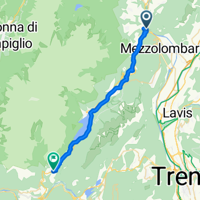
Mezzolombardo-San Lorenzo in Banale
A cycling route starting in Spormaggiore, Trentino-Alto Adige, Italy.
Overview
About this route
- -:--
- Duration
- 27.4 km
- Distance
- 844 m
- Ascent
- 420 m
- Descent
- ---
- Avg. speed
- ---
- Max. altitude

Route quality
Waytypes & surfaces along the route
Waytypes
Quiet road
9.5 km
(35 %)
Path
7.1 km
(26 %)
Surfaces
Paved
12.7 km
(46 %)
Unpaved
7.2 km
(26 %)
Asphalt
10.2 km
(37 %)
Gravel
3.4 km
(12 %)
Continue with Bikemap
Use, edit, or download this cycling route
You would like to ride Mezzolombardo-San Lorenzo in Banale or customize it for your own trip? Here is what you can do with this Bikemap route:
Free features
- Save this route as favorite or in collections
- Copy & plan your own version of this route
- Sync your route with Garmin or Wahoo
Premium features
Free trial for 3 days, or one-time payment. More about Bikemap Premium.
- Navigate this route on iOS & Android
- Export a GPX / KML file of this route
- Create your custom printout (try it for free)
- Download this route for offline navigation
Discover more Premium features.
Get Bikemap PremiumFrom our community
Other popular routes starting in Spormaggiore
 Mezzocorona-Andalo-Molveno-Sarche
- Distance
- 97.4 km
- Ascent
- 2,930 m
- Descent
- 2,947 m
- Location
- Spormaggiore, Trentino-Alto Adige, Italy
 La Roccheta-Andola-Molveno-Ballino-Varone
- Distance
- 63.6 km
- Ascent
- 1,168 m
- Descent
- 1,289 m
- Location
- Spormaggiore, Trentino-Alto Adige, Italy
 RIVAdo
- Distance
- 55.8 km
- Ascent
- 852 m
- Descent
- 1,446 m
- Location
- Spormaggiore, Trentino-Alto Adige, Italy
 Mezzolombardo-San Lorenzo in Banale
- Distance
- 27.4 km
- Ascent
- 844 m
- Descent
- 420 m
- Location
- Spormaggiore, Trentino-Alto Adige, Italy
 Mezzolombardo -- Andalo
- Distance
- 15 km
- Ascent
- 783 m
- Descent
- 39 m
- Location
- Spormaggiore, Trentino-Alto Adige, Italy
 La Rochella - Andalo klim
- Distance
- 13.5 km
- Ascent
- 794 m
- Descent
- 28 m
- Location
- Spormaggiore, Trentino-Alto Adige, Italy
 2015-06-29 TRANSALP DAY 5
- Distance
- 73.5 km
- Ascent
- 895 m
- Descent
- 1,286 m
- Location
- Spormaggiore, Trentino-Alto Adige, Italy
 Giro delle Dolomiti del Brenta AO
- Distance
- 132.5 km
- Ascent
- 3,559 m
- Descent
- 3,532 m
- Location
- Spormaggiore, Trentino-Alto Adige, Italy
Open it in the app