

1st Day_PlanB
A cycling route starting in Banqiao District, Taipei, Taiwan.
Overview
About this route
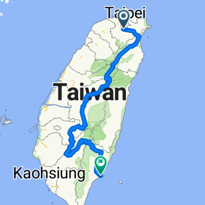
1st Day
Distance: 106.95 km
Altitude: 470 hm
- -:--
- Duration
- 107 km
- Distance
- 375 m
- Ascent
- 377 m
- Descent
- ---
- Avg. speed
- ---
- Max. altitude

Route quality
Waytypes & surfaces along the route
Waytypes
Busy road
36.9 km
(34 %)
Road
36.4 km
(34 %)
Surfaces
Paved
41.6 km
(39 %)
Asphalt
40.5 km
(38 %)
Paved (undefined)
1.1 km
(<1 %)
Continue with Bikemap
Use, edit, or download this cycling route
You would like to ride 1st Day_PlanB or customize it for your own trip? Here is what you can do with this Bikemap route:
Free features
- Save this route as favorite or in collections
- Copy & plan your own version of this route
- Split it into stages to create a multi-day tour
- Sync your route with Garmin or Wahoo
Premium features
Free trial for 3 days, or one-time payment. More about Bikemap Premium.
- Navigate this route on iOS & Android
- Export a GPX / KML file of this route
- Create your custom printout (try it for free)
- Download this route for offline navigation
Discover more Premium features.
Get Bikemap PremiumFrom our community
Other popular routes starting in Banqiao District
 中央山脈一條鞭
- Distance
- 690.1 km
- Ascent
- 8,446 m
- Descent
- 8,466 m
- Location
- Banqiao District, Taipei, Taiwan
 01/05/2019一日北高
- Distance
- 361.5 km
- Ascent
- 107 m
- Descent
- 108 m
- Location
- Banqiao District, Taipei, Taiwan
![[五星]分段環島-首部曲-永和到清水](https://media.bikemap.net/routes/98905/staticmaps/in_cba9c0d3-caf2-4f27-b1e4-472c0ba70923_400x400_bikemap-2021-3D-static.png) [五星]分段環島-首部曲-永和到清水
[五星]分段環島-首部曲-永和到清水- Distance
- 172.5 km
- Ascent
- 332 m
- Descent
- 340 m
- Location
- Banqiao District, Taipei, Taiwan
 烏來老街 ↔ 福山
- Distance
- 17 km
- Ascent
- 750 m
- Descent
- 479 m
- Location
- Banqiao District, Taipei, Taiwan
 一日北高
一日北高- Distance
- 362.1 km
- Ascent
- 310 m
- Descent
- 313 m
- Location
- Banqiao District, Taipei, Taiwan
 新店_(台9)坪林_106乙(石碇)_環圈
- Distance
- 59.8 km
- Ascent
- 2,096 m
- Descent
- 2,095 m
- Location
- Banqiao District, Taipei, Taiwan
 中和-三芝櫻花道-北投-中和
- Distance
- 87.8 km
- Ascent
- 721 m
- Descent
- 721 m
- Location
- Banqiao District, Taipei, Taiwan
 北42/北43"藍鵲"公路
- Distance
- 90 km
- Ascent
- 1,049 m
- Descent
- 1,042 m
- Location
- Banqiao District, Taipei, Taiwan
Open it in the app