

Schmiedenmatt Tannmatt
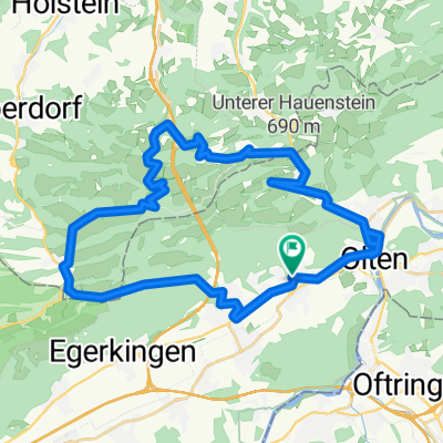
A cycling route starting in Wangen, Canton of Solothurn, Switzerland.
Overview
About this route
Crisp Jura hills
- -:--
- Duration
- 78 km
- Distance
- 1,190 m
- Ascent
- 1,192 m
- Descent
- ---
- Avg. speed
- ---
- Max. altitude

Route quality
Waytypes & surfaces along the route
Waytypes
Quiet road
37.4 km
(48 %)
Track
10.9 km
(14 %)
Surfaces
Paved
58.5 km
(75 %)
Unpaved
5.5 km
(7 %)
Asphalt
56.9 km
(73 %)
Gravel
3.1 km
(4 %)
Continue with Bikemap
Use, edit, or download this cycling route
You would like to ride Schmiedenmatt Tannmatt or customize it for your own trip? Here is what you can do with this Bikemap route:
Free features
- Save this route as favorite or in collections
- Copy & plan your own version of this route
- Sync your route with Garmin or Wahoo
Premium features
Free trial for 3 days, or one-time payment. More about Bikemap Premium.
- Navigate this route on iOS & Android
- Export a GPX / KML file of this route
- Create your custom printout (try it for free)
- Download this route for offline navigation
Discover more Premium features.
Get Bikemap PremiumFrom our community
Other popular routes starting in Wangen
 Egerkignen, Belchenflue, Wangen b. Olten
- Distance
- 33.5 km
- Ascent
- 1,060 m
- Descent
- 1,061 m
- Location
- Wangen, Canton of Solothurn, Switzerland
 Allerheiligen Wangen
- Distance
- 25.5 km
- Ascent
- 777 m
- Descent
- 729 m
- Location
- Wangen, Canton of Solothurn, Switzerland
 Allerheiligen, Holderbank, Oberbuchsiten, Wangen
- Distance
- 18.7 km
- Ascent
- 764 m
- Descent
- 731 m
- Location
- Wangen, Canton of Solothurn, Switzerland
 Wangen, Nebikon, Trimbach
- Distance
- 59.2 km
- Ascent
- 1,016 m
- Descent
- 991 m
- Location
- Wangen, Canton of Solothurn, Switzerland
 Niedergösgen, Aarau, Wangen b. Olten
- Distance
- 39.5 km
- Ascent
- 252 m
- Descent
- 251 m
- Location
- Wangen, Canton of Solothurn, Switzerland
 Langenbruck - Chesselberg
- Distance
- 39.9 km
- Ascent
- 990 m
- Descent
- 990 m
- Location
- Wangen, Canton of Solothurn, Switzerland
 Fulenbach , Roggwill, Zofingen, Wangen
- Distance
- 43.7 km
- Ascent
- 362 m
- Descent
- 362 m
- Location
- Wangen, Canton of Solothurn, Switzerland
 Wangen, Kölliken, Erlinsbach, Lostorf, Wangen
- Distance
- 46.7 km
- Ascent
- 1,068 m
- Descent
- 1,067 m
- Location
- Wangen, Canton of Solothurn, Switzerland
Open it in the app