

Felfedező út Solymár felé
A cycling route starting in Budapest XII. kerület, Budapest, Hungary.
Overview
About this route
The route is acceptable up to the northeastern corner of Solymár, with some nice sections towards Szénások, but after Solymár the Bécsi út is a disaster. The streets marked on the map disappeared during the railway renovation, and the situation around Bécsi út is now even worse. I also had to ride there for a while. There is a brook, but the traffic is catastrophic.
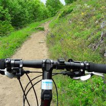
Route: up to the large Hűvösvölgyi meadow as usual, then the marked bike path runs a long way through small suburban streets. After Zsíros hill the route is unclear; a steep climb leads towards Szénások, and you have to push your bike because it's so dusty and gravelly. And riding a bike there is also prohibited. Nagy-Szénás is a very beautiful place; there is a rest area at the old tourist house monument. From here I left the marked big loop (blue sign) and took the yellow trail down towards Pilisszentiván. Here the road goes through a narrower valley. While avoiding a fallen tree, I fell because it was very steep. Once reaching the inhabited area, the excitement disappears, and boring small streets follow. The fishing lake is nice, the mining lakes less so (surrounded by shacks). The road from Pilisvörösvár to Solymár is quite good. An agricultural dirt road along the ridge, parallel to the railway. Beautiful view, nice surroundings. But from here everything ends. From here on I cycled along with cars :( With a heavy heart I looked to the right where the border mountain number 3 can be seen and my usual beautiful route. I tried to leave the Bécsi út as soon as possible and turned towards Csillaghegy. Finally, under the Békásmegyeri HÉV underpass, I got to the civilized side and sped straight down to the Danube shore. At this point I was so hungry that I decided to ride to Szentendre for a meal. I stopped by Gábor's for a good barbecue. Around 5 pm I set off home because I didn't have lights. From there I took the usual Szentendre-Budapest bike path and got home in 2 hours.
- 7 h 59 min
- Duration
- 96.9 km
- Distance
- 772 m
- Ascent
- 781 m
- Descent
- 12.1 km/h
- Avg. speed
- ---
- Max. altitude

Route quality
Waytypes & surfaces along the route
Waytypes
Quiet road
24.2 km
(25 %)
Cycleway
18.4 km
(19 %)
Surfaces
Paved
62 km
(64 %)
Unpaved
18.4 km
(19 %)
Asphalt
60.1 km
(62 %)
Gravel
8.7 km
(9 %)
Route highlights
Points of interest along the route
Point of interest after 21.9 km
etterem, egyszintes szuperhaz

Point of interest after 22.2 km

Point of interest after 22.2 km

Point of interest after 22.6 km

Point of interest after 24.8 km
Point of interest after 24.9 km
szep hely. piheno. szep osveny. balra szenasok.

Point of interest after 25 km

Point of interest after 25 km

Point of interest after 25 km
Point of interest after 26.2 km
elestem

Point of interest after 26.2 km

Point of interest after 30 km

Point of interest after 30.1 km

Point of interest after 33.9 km

Point of interest after 33.9 km
Point of interest after 37.1 km
itt rohadtul nincs arjaro

Point of interest after 38.8 km

Point of interest after 38.8 km
Continue with Bikemap
Use, edit, or download this cycling route
You would like to ride Felfedező út Solymár felé or customize it for your own trip? Here is what you can do with this Bikemap route:
Free features
- Save this route as favorite or in collections
- Copy & plan your own version of this route
- Split it into stages to create a multi-day tour
- Sync your route with Garmin or Wahoo
Premium features
Free trial for 3 days, or one-time payment. More about Bikemap Premium.
- Navigate this route on iOS & Android
- Export a GPX / KML file of this route
- Create your custom printout (try it for free)
- Download this route for offline navigation
Discover more Premium features.
Get Bikemap PremiumFrom our community
Other popular routes starting in Budapest XII. kerület
 @HU: Kis-Sváb-hegytől HHH-ig, 20009-06-13
- Distance
- 23.2 km
- Ascent
- 705 m
- Descent
- 404 m
- Location
- Budapest XII. kerület, Budapest, Hungary
 Felfedező út Solymár felé
- Distance
- 96.9 km
- Ascent
- 772 m
- Descent
- 781 m
- Location
- Budapest XII. kerület, Budapest, Hungary
 Nagy-kopasz - tervezet
- Distance
- 32.7 km
- Ascent
- 618 m
- Descent
- 620 m
- Location
- Budapest XII. kerület, Budapest, Hungary
 Januári Szénás János
- Distance
- 48.3 km
- Ascent
- 811 m
- Descent
- 821 m
- Location
- Budapest XII. kerület, Budapest, Hungary
 Favourite spring trip from Gazdagret
- Distance
- 65.9 km
- Ascent
- 587 m
- Descent
- 412 m
- Location
- Budapest XII. kerület, Budapest, Hungary
 Dobogőkő-kör
- Distance
- 81.7 km
- Ascent
- 839 m
- Descent
- 839 m
- Location
- Budapest XII. kerület, Budapest, Hungary
 Szokasos kor, ezuttal esoben
- Distance
- 40.9 km
- Ascent
- 611 m
- Descent
- 611 m
- Location
- Budapest XII. kerület, Budapest, Hungary
 Pedal do Sabado
- Distance
- 53.5 km
- Ascent
- 766 m
- Descent
- 767 m
- Location
- Budapest XII. kerület, Budapest, Hungary
Open it in the app