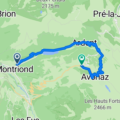
Avoriaz and above to Col du Fornet
A cycling route starting in Morzine, Auvergne-Rh么ne-Alpes, France.
Overview
About this route
Paved until Avoriaz, very rough above to Swiss border cols
- -:--
- Duration
- 47.9 km
- Distance
- 1,535 m
- Ascent
- 1,530 m
- Descent
- ---
- Avg. speed
- ---
- Avg. speed
Route photos
Route quality
Waytypes & surfaces along the route
Waytypes
Undefined
47.9 km
(100 %)
Surfaces
Undefined
47.9 km
(100 %)
Route highlights
Points of interest along the route
Point of interest after 19.6 km
Avoriaz
Point of interest after 26 km
Pas de Chavanette - 2146 metres
Point of interest after 28.5 km
Col du Fornet - 2227 metres
Point of interest after 34.2 km
Col de la Joux Verte
Continue with Bikemap
Use, edit, or download this cycling route
You would like to ride Avoriaz and above to Col du Fornet or customize it for your own trip? Here is what you can do with this Bikemap route:
Free features
- Save this route as favorite or in collections
- Copy & plan your own version of this route
- Sync your route with Garmin or Wahoo
Premium features
Free trial for 3 days, or one-time payment. More about Bikemap Premium.
- Navigate this route on iOS & Android
- Export a GPX / KML file of this route
- Create your custom printout (try it for free)
- Download this route for offline navigation
Discover more Premium features.
Get Bikemap PremiumFrom our community
Other popular routes starting in Morzine
- Day 1
- Distance
- 137.6 km
- Ascent
- 3,476 m
- Descent
- 3,461 m
- Location
- Morzine, Auvergne-Rh么ne-Alpes, France
- Morzine - Col de la Ramaz - Col de la Colombi猫re
- Distance
- 133.7 km
- Ascent
- 2,660 m
- Descent
- 2,654 m
- Location
- Morzine, Auvergne-Rh么ne-Alpes, France
- Avoriaz and above to Col du Fornet
- Distance
- 47.9 km
- Ascent
- 1,535 m
- Descent
- 1,530 m
- Location
- Morzine, Auvergne-Rh么ne-Alpes, France
- gets rondje
- Distance
- 44.5 km
- Ascent
- 1,626 m
- Descent
- 1,574 m
- Location
- Morzine, Auvergne-Rh么ne-Alpes, France
- Morzine-Avoriaz
- Distance
- 29.2 km
- Ascent
- 922 m
- Descent
- 906 m
- Location
- Morzine, Auvergne-Rh么ne-Alpes, France
- Morzine - Col de la Joux Verte
- Distance
- 30.3 km
- Ascent
- 861 m
- Descent
- 861 m
- Location
- Morzine, Auvergne-Rh么ne-Alpes, France
- Tour d'Enfer : Day 1 - Morzine to La Clusaz
- Distance
- 75.7 km
- Ascent
- 1,814 m
- Descent
- 1,629 m
- Location
- Morzine, Auvergne-Rh么ne-Alpes, France
- Alps Three Peaks Challenge Col de Joux Verte, Col de Jeu Plane, Col de l'Encrenaz
- Distance
- 76 km
- Ascent
- 2,340 m
- Descent
- 2,347 m
- Location
- Morzine, Auvergne-Rh么ne-Alpes, France