

2016 Ride Day 161 - Rivière-sur-Tarn to Boyne
A cycling route starting in Millau, Languedoc-Roussillon-Midi-Pyrénées, France.
Overview
About this route
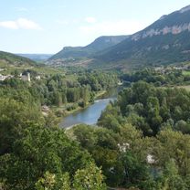
We had only a short way to go to our next lodging along wtih a terrible weather forecase for the afternoon. So, we did a short cirlcle to allow us a nice ride with less chance of being dumped on. In the end, we were lucky.
D547 through Compeyre was a short climb with no traffic an very nice views. D809 is a long climb with a lttle good scenery. It climbs to the Col d'Engayresque at 888M. D809 was presumably a major road prior to the completion of the mostly parallel major highway leading south to the Millau Viaduct. Now, though, it's little used with almost no cars on it.
D94 was an outstanding downhill going through forests on the way. Great descent.
Highly recommend.
- -:--
- Duration
- 33.8 km
- Distance
- 590 m
- Ascent
- 576 m
- Descent
- ---
- Avg. speed
- ---
- Avg. speed

Route photos


Route quality
Waytypes & surfaces along the route
Waytypes
Busy road
16.5 km
(49 %)
Road
14.8 km
(44 %)
Surfaces
Paved
21.5 km
(63 %)
Unpaved
0.5 km
(2 %)
Asphalt
21.5 km
(63 %)
Unpaved (undefined)
0.5 km
(2 %)
Undefined
11.8 km
(35 %)
Continue with Bikemap
Use, edit, or download this cycling route
You would like to ride 2016 Ride Day 161 - Rivière-sur-Tarn to Boyne or customize it for your own trip? Here is what you can do with this Bikemap route:
Free features
- Save this route as favorite or in collections
- Copy & plan your own version of this route
- Sync your route with Garmin or Wahoo
Premium features
Free trial for 3 days, or one-time payment. More about Bikemap Premium.
- Navigate this route on iOS & Android
- Export a GPX / KML file of this route
- Create your custom printout (try it for free)
- Download this route for offline navigation
Discover more Premium features.
Get Bikemap PremiumFrom our community
Other popular routes starting in Millau
 2016 Ride Day 161 - Rivière-sur-Tarn to Boyne
- Distance
- 33.8 km
- Ascent
- 590 m
- Descent
- 576 m
- Location
- Millau, Languedoc-Roussillon-Midi-Pyrénées, France
 4 Millau viaduct extension
- Distance
- 12.2 km
- Ascent
- 155 m
- Descent
- 158 m
- Location
- Millau, Languedoc-Roussillon-Midi-Pyrénées, France
 2016 Ride Day 162 - Boyne - Circle to Gorges du Tarn
- Distance
- 70.6 km
- Ascent
- 924 m
- Descent
- 924 m
- Location
- Millau, Languedoc-Roussillon-Midi-Pyrénées, France
 2016 Ride Day 165 - Millau to Rullac-Saint-Cirq
- Distance
- 94 km
- Ascent
- 984 m
- Descent
- 875 m
- Location
- Millau, Languedoc-Roussillon-Midi-Pyrénées, France
 2016 Ride Day 135 - Millau to Banassac
- Distance
- 58.4 km
- Ascent
- 856 m
- Descent
- 761 m
- Location
- Millau, Languedoc-Roussillon-Midi-Pyrénées, France
 Etape 10 - Millau à Bédouès - 82,8km 770D+
- Distance
- 76.7 km
- Ascent
- 902 m
- Descent
- 699 m
- Location
- Millau, Languedoc-Roussillon-Midi-Pyrénées, France
 Untitled route
- Distance
- 200.1 km
- Ascent
- 4,305 m
- Descent
- 4,574 m
- Location
- Millau, Languedoc-Roussillon-Midi-Pyrénées, France
 2019-11 Millau to Meyrueis
- Distance
- 42.7 km
- Ascent
- 483 m
- Descent
- 230 m
- Location
- Millau, Languedoc-Roussillon-Midi-Pyrénées, France
Open it in the app