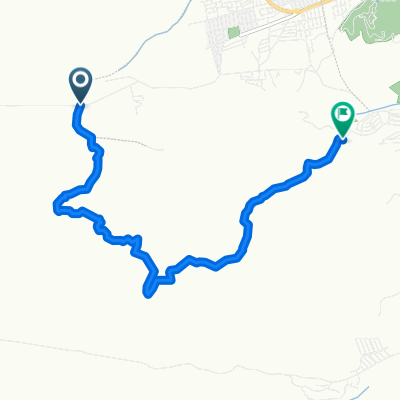
RUTADELBIKER - Copa Municipalidad de Godoy Cruz
A cycling route starting in Godoy Cruz, Mendoza Province, Argentina.
Overview
About this route
La RUTADELBIKER es un rally MTB punto a punto que larga sobre el paredón del Dique Frías, cruza por senderos hacia el SUR a la zona de Chacras y finaliza en La Estación Parque Benegas. Es un verdadero cruce del pedemonte que une las zonas a través de espectaculares senderos para andar en bicicleta de montaña. Una fusión única senderos del FRIAS y de CHACRAS.
No dejes pasar la RUTADELBIKER, es una carrera completa!!!
Distancias / categorias
37,5 km / Elite, Sub 23, Juveniles, Master A1-A2, Master B1-B2, Master C1-C2, Damas Elite, Damas A, Damas B
24,5 km / Damas C, Damas Promo, Master D, Menores, Cadetes, Promo A, Promo B.
- -:--
- Duration
- 37.5 km
- Distance
- 556 m
- Ascent
- 617 m
- Descent
- ---
- Avg. speed
- ---
- Max. altitude
Route highlights
Points of interest along the route
Point of interest after 12.9 km
Desvio por SENDERO DEDO PINCHADO de las Categorias: Damas C, Damas Promo, Master D, Menores, Cadetes, Promo A y B Senderos a seguir, dedo pinchado, picada 2, sendero de la lagunita, camino que va a la base del telegrafito, telegrafito, descenso por la guanaca, corredor del oeste.
Continue with Bikemap
Use, edit, or download this cycling route
You would like to ride RUTADELBIKER - Copa Municipalidad de Godoy Cruz or customize it for your own trip? Here is what you can do with this Bikemap route:
Free features
- Save this route as favorite or in collections
- Copy & plan your own version of this route
- Sync your route with Garmin or Wahoo
Premium features
Free trial for 3 days, or one-time payment. More about Bikemap Premium.
- Navigate this route on iOS & Android
- Export a GPX / KML file of this route
- Create your custom printout (try it for free)
- Download this route for offline navigation
Discover more Premium features.
Get Bikemap PremiumFrom our community
Other popular routes starting in Godoy Cruz
 la guanaca 2
- Distance
- 5.5 km
- Ascent
- 205 m
- Descent
- 201 m
- Location
- Godoy Cruz, Mendoza Province, Argentina
 Frias a la manera del PussyTeam
- Distance
- 25.6 km
- Ascent
- 96 m
- Descent
- 695 m
- Location
- Godoy Cruz, Mendoza Province, Argentina
 Camino al puesto del Peral
- Distance
- 12.7 km
- Ascent
- 672 m
- Descent
- 0 m
- Location
- Godoy Cruz, Mendoza Province, Argentina
 La Campanita
- Distance
- 109.4 km
- Ascent
- 756 m
- Descent
- 756 m
- Location
- Godoy Cruz, Mendoza Province, Argentina
 Caño colgante, colonia, el Dibu y abajo :)
- Distance
- 18.4 km
- Ascent
- 110 m
- Descent
- 702 m
- Location
- Godoy Cruz, Mendoza Province, Argentina
 Barcito con Lluvia
- Distance
- 22 km
- Ascent
- 194 m
- Descent
- 956 m
- Location
- Godoy Cruz, Mendoza Province, Argentina
 la guanaca 1
- Distance
- 6.6 km
- Ascent
- 154 m
- Descent
- 163 m
- Location
- Godoy Cruz, Mendoza Province, Argentina
 frias largo
- Distance
- 8.9 km
- Ascent
- 54 m
- Descent
- 234 m
- Location
- Godoy Cruz, Mendoza Province, Argentina
Open it in the app


