

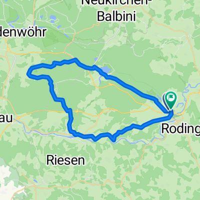
Regentour
A cycling route starting in Roding, Bavaria, Germany.
Overview
About this route
Von Roding nach Nittenau und zurück! Erster Stopp an
der Wallfahrtskirche Heilbrünnl. Steile Abfahrt auf lockerer
Sandstraße (10 km/h!!). Bei Rückfahrt über Zenzig Langer Anstieg und lange Abfahrt nach Roding.
- -:--
- Duration
- 44.2 km
- Distance
- 416 m
- Ascent
- 415 m
- Descent
- ---
- Avg. speed
- ---
- Max. altitude
Route quality
Waytypes & surfaces along the route
Waytypes
Quiet road
17.6 km
(40 %)
Track
10.1 km
(23 %)
Surfaces
Paved
20.7 km
(47 %)
Unpaved
6.8 km
(15 %)
Asphalt
17.2 km
(39 %)
Gravel
6 km
(14 %)
Route highlights
Points of interest along the route
Point of interest after 2.6 km
Helbrünnl
Continue with Bikemap
Use, edit, or download this cycling route
You would like to ride Regentour or customize it for your own trip? Here is what you can do with this Bikemap route:
Free features
- Save this route as favorite or in collections
- Copy & plan your own version of this route
- Sync your route with Garmin or Wahoo
Premium features
Free trial for 3 days, or one-time payment. More about Bikemap Premium.
- Navigate this route on iOS & Android
- Export a GPX / KML file of this route
- Create your custom printout (try it for free)
- Download this route for offline navigation
Discover more Premium features.
Get Bikemap PremiumFrom our community
Other popular routes starting in Roding
 Höllgasse, Roding nach Altenmarkter Straße, Cham
- Distance
- 16.2 km
- Ascent
- 81 m
- Descent
- 75 m
- Location
- Roding, Bavaria, Germany
 Kalkbrennerweg 2, Roding nach Dr.-Götz-Straße 1, Falkenstein
- Distance
- 15 km
- Ascent
- 507 m
- Descent
- 307 m
- Location
- Roding, Bavaria, Germany
 Regentour
- Distance
- 44.2 km
- Ascent
- 416 m
- Descent
- 415 m
- Location
- Roding, Bavaria, Germany
 Roding - Miltach
- Distance
- 29.8 km
- Ascent
- 120 m
- Descent
- 135 m
- Location
- Roding, Bavaria, Germany
 #8_Roding_Regensburg
- Distance
- 50.1 km
- Ascent
- 358 m
- Descent
- 407 m
- Location
- Roding, Bavaria, Germany
 nach Sollbach
- Distance
- 36.9 km
- Ascent
- 543 m
- Descent
- 544 m
- Location
- Roding, Bavaria, Germany
 Roding-Regensburg
- Distance
- 64.7 km
- Ascent
- 723 m
- Descent
- 771 m
- Location
- Roding, Bavaria, Germany
 Roding - Furth im Walde
- Distance
- 36.7 km
- Ascent
- 123 m
- Descent
- 86 m
- Location
- Roding, Bavaria, Germany
Open it in the app