

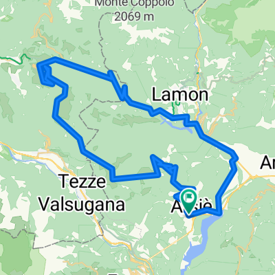
Col Maldoni
A cycling route starting in Arsiè, Veneto, Italy.
Overview
About this route
On the SP38 over the mountains into the Brenta Valley
- -:--
- Duration
- 66.6 km
- Distance
- 1,535 m
- Ascent
- 1,530 m
- Descent
- ---
- Avg. speed
- ---
- Max. altitude

Continue with Bikemap
Use, edit, or download this cycling route
You would like to ride Col Maldoni or customize it for your own trip? Here is what you can do with this Bikemap route:
Free features
- Save this route as favorite or in collections
- Copy & plan your own version of this route
- Sync your route with Garmin or Wahoo
Premium features
Free trial for 3 days, or one-time payment. More about Bikemap Premium.
- Navigate this route on iOS & Android
- Export a GPX / KML file of this route
- Create your custom printout (try it for free)
- Download this route for offline navigation
Discover more Premium features.
Get Bikemap PremiumFrom our community
Other popular routes starting in Arsiè
 Arsiè La Roa Cima Campo
- Distance
- 58.4 km
- Ascent
- 2,148 m
- Descent
- 1,997 m
- Location
- Arsiè, Veneto, Italy
 Arsiè M.te Grappa Bassano Arsiè
- Distance
- 91.6 km
- Ascent
- 2,174 m
- Descent
- 2,194 m
- Location
- Arsiè, Veneto, Italy
 Arsie-Padorna del Grappa
- Distance
- 36.4 km
- Ascent
- 1,675 m
- Descent
- 1,616 m
- Location
- Arsiè, Veneto, Italy
 IL GRAPPA VERO ALANO
- Distance
- 92.7 km
- Ascent
- 1,778 m
- Descent
- 1,778 m
- Location
- Arsiè, Veneto, Italy
 Giro del lago del Corlo (parte diga)
- Distance
- 10.4 km
- Ascent
- 491 m
- Descent
- 491 m
- Location
- Arsiè, Veneto, Italy
 Lago - Brenta
- Distance
- 43.1 km
- Ascent
- 971 m
- Descent
- 968 m
- Location
- Arsiè, Veneto, Italy
 Col Maldoni
- Distance
- 66.6 km
- Ascent
- 1,535 m
- Descent
- 1,530 m
- Location
- Arsiè, Veneto, Italy
 20170726_114248.gpx
- Distance
- 65.8 km
- Ascent
- 922 m
- Descent
- 922 m
- Location
- Arsiè, Veneto, Italy
Open it in the app