

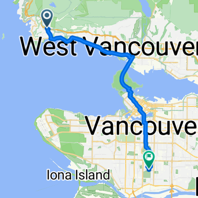
Kurze Radrunde vom 28. September, 09:32
A cycling route starting in West Vancouver, British Columbia, Canada.
Overview
About this route
- 1 h 49 min
- Duration
- 3.3 km
- Distance
- 805 m
- Ascent
- 13 m
- Descent
- 1.8 km/h
- Avg. speed
- ---
- Max. altitude
Continue with Bikemap
Use, edit, or download this cycling route
You would like to ride Kurze Radrunde vom 28. September, 09:32 or customize it for your own trip? Here is what you can do with this Bikemap route:
Free features
- Save this route as favorite or in collections
- Copy & plan your own version of this route
- Sync your route with Garmin or Wahoo
Premium features
Free trial for 3 days, or one-time payment. More about Bikemap Premium.
- Navigate this route on iOS & Android
- Export a GPX / KML file of this route
- Create your custom printout (try it for free)
- Download this route for offline navigation
Discover more Premium features.
Get Bikemap PremiumFrom our community
Other popular routes starting in West Vancouver
 4749 Rutland Rd, West Vancouver to 100 W 49th Ave, Vancouver
- Distance
- 24.5 km
- Ascent
- 268 m
- Descent
- 343 m
- Location
- West Vancouver, British Columbia, Canada
 Cypress
- Distance
- 15.7 km
- Ascent
- 744 m
- Descent
- 19 m
- Location
- West Vancouver, British Columbia, Canada
 New Challenge
- Distance
- 179.4 km
- Ascent
- 1,190 m
- Descent
- 1,191 m
- Location
- West Vancouver, British Columbia, Canada
 Seven Bridges
- Distance
- 78.8 km
- Ascent
- 589 m
- Descent
- 589 m
- Location
- West Vancouver, British Columbia, Canada
 Cypress Mountain
- Distance
- 15.2 km
- Ascent
- 823 m
- Descent
- 64 m
- Location
- West Vancouver, British Columbia, Canada
 1495 Bellevue Ave, West Vancouver to 5385 Headland Dr, West Vancouver
- Distance
- 8.9 km
- Ascent
- 252 m
- Descent
- 84 m
- Location
- West Vancouver, British Columbia, Canada
 807 Main St, Capilano 5 to 4749 Rutland Rd, West Vancouver
- Distance
- 10.4 km
- Ascent
- 254 m
- Descent
- 121 m
- Location
- West Vancouver, British Columbia, Canada
 Relaxed route in West Vancouver
- Distance
- 17.7 km
- Ascent
- 0 m
- Descent
- 9 m
- Location
- West Vancouver, British Columbia, Canada
Open it in the app