
Krasznahorka-Kassa - 160929 - IIG
A cycling route starting in Szendrő, Borsod-Abauj Zemplen county, Hungary.
Overview
About this route
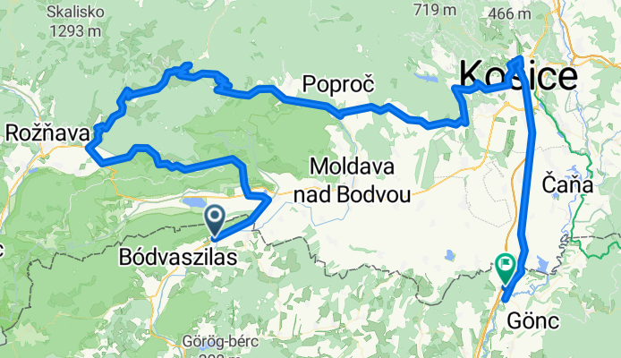
Tornanádaska - Szádelői-völgy - Krasznahorka - Szomolnok - Kassa - Hidasnémeti
- -:--
- Duration
- 149.9 km
- Distance
- 1,559 m
- Ascent
- 1,563 m
- Descent
- ---
- Avg. speed
- ---
- Max. altitude

Continue with Bikemap
Use, edit, or download this cycling route
You would like to ride Krasznahorka-Kassa - 160929 - IIG or customize it for your own trip? Here is what you can do with this Bikemap route:
Free features
- Save this route as favorite or in collections
- Copy & plan your own version of this route
- Split it into stages to create a multi-day tour
- Sync your route with Garmin or Wahoo
Premium features
Free trial for 3 days, or one-time payment. More about Bikemap Premium.
- Navigate this route on iOS & Android
- Export a GPX / KML file of this route
- Create your custom printout (try it for free)
- Download this route for offline navigation
Discover more Premium features.
Get Bikemap PremiumFrom our community
Other popular routes starting in Szendrő
 Tornanádaska-Szádellői völgy-Krasznahorka-Bódvaszilas
- Distance
- 79.7 km
- Ascent
- 814 m
- Descent
- 814 m
- Location
- Szendrő, Borsod-Abauj Zemplen county, Hungary
 Északi Zöld 08
- Distance
- 18 km
- Ascent
- 513 m
- Descent
- 451 m
- Location
- Szendrő, Borsod-Abauj Zemplen county, Hungary
 Szögliget, Vidomáj-puszta, Körtvélyes, Jablonca, Szilice, Szádvárborsa, Kecső, Domica-barlang, Aggtelek, Jósvafő, Szinpetri, Szin, Szögliget
- Distance
- 157.3 km
- Ascent
- 1,120 m
- Descent
- 1,120 m
- Location
- Szendrő, Borsod-Abauj Zemplen county, Hungary
 Aggtelek
- Distance
- 59.5 km
- Ascent
- 1,176 m
- Descent
- 1,172 m
- Location
- Szendrő, Borsod-Abauj Zemplen county, Hungary
 Szalonna - Encs bringatúra !
- Distance
- 53.7 km
- Ascent
- 266 m
- Descent
- 276 m
- Location
- Szendrő, Borsod-Abauj Zemplen county, Hungary
 Aggtelek 6.
- Distance
- 6.2 km
- Ascent
- 7 m
- Descent
- 58 m
- Location
- Szendrő, Borsod-Abauj Zemplen county, Hungary
 OKT Csereháti Kék 1
- Distance
- 26.4 km
- Ascent
- 431 m
- Descent
- 411 m
- Location
- Szendrő, Borsod-Abauj Zemplen county, Hungary
 Hámorok Túra 1.nap
- Distance
- 64.3 km
- Ascent
- 1,093 m
- Descent
- 908 m
- Location
- Szendrő, Borsod-Abauj Zemplen county, Hungary
Open it in the app