

TRACK3
A cycling route starting in Bonansa, Aragon, Spain.
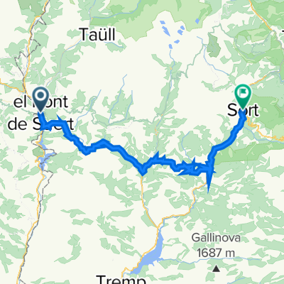
Overview
About this route
- -:--
- Duration
- 74 km
- Distance
- 1,083 m
- Ascent
- 1,396 m
- Descent
- ---
- Avg. speed
- ---
- Max. altitude

Route highlights
Points of interest along the route
Point of interest after 39.3 km
ALBERGUE PAJARO LOCO
Continue with Bikemap
Use, edit, or download this cycling route
You would like to ride TRACK3 or customize it for your own trip? Here is what you can do with this Bikemap route:
Free features
- Save this route as favorite or in collections
- Copy & plan your own version of this route
- Sync your route with Garmin or Wahoo
Premium features
Free trial for 3 days, or one-time payment. More about Bikemap Premium.
- Navigate this route on iOS & Android
- Export a GPX / KML file of this route
- Create your custom printout (try it for free)
- Download this route for offline navigation
Discover more Premium features.
Get Bikemap PremiumFrom our community
Other popular routes starting in Bonansa
 Pont de Suert to Campo via Castejon de Sos
- Distance
- 55.4 km
- Ascent
- 839 m
- Descent
- 1,010 m
- Location
- Bonansa, Aragon, Spain
 El Pont de Suert - Tarragona
- Distance
- 207.9 km
- Ascent
- 1,990 m
- Descent
- 2,833 m
- Location
- Bonansa, Aragon, Spain
 Transpirenaica.Etapa9.Sentis-Senz
- Distance
- 58 km
- Ascent
- 1,635 m
- Descent
- 1,568 m
- Location
- Bonansa, Aragon, Spain
 Las Herrerías de Calvera-Monzón. Junio 2017
- Distance
- 85.1 km
- Ascent
- 224 m
- Descent
- 924 m
- Location
- Bonansa, Aragon, Spain
 ETAPA 1
- Distance
- 154.5 km
- Ascent
- 2,277 m
- Descent
- 2,410 m
- Location
- Bonansa, Aragon, Spain
 circular btt-monasterio de obarra
- Distance
- 51.3 km
- Ascent
- 1,116 m
- Descent
- 1,106 m
- Location
- Bonansa, Aragon, Spain
 de hostal canigo el pont de suert a can congost sort 19juin
- Distance
- 60 km
- Ascent
- 1,485 m
- Descent
- 1,637 m
- Location
- Bonansa, Aragon, Spain
 El Pont de Suert - Pic del Maià
- Distance
- 183.7 km
- Ascent
- 4,283 m
- Descent
- 2,606 m
- Location
- Bonansa, Aragon, Spain
Open it in the app