

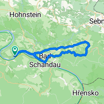
ELBERADWEG KOENIGSTEIN DOLNI GRUND
A cycling route starting in Königstein, Saxony, Germany.
Overview
About this route
TEASI track
- -:--
- Duration
- 40.7 km
- Distance
- 392 m
- Ascent
- 375 m
- Descent
- ---
- Avg. speed
- ---
- Max. altitude

Route quality
Waytypes & surfaces along the route
Waytypes
Cycleway
13 km
(32 %)
Quiet road
9.8 km
(24 %)
Surfaces
Paved
35 km
(86 %)
Unpaved
2.4 km
(6 %)
Asphalt
34.2 km
(84 %)
Loose gravel
1.6 km
(4 %)
Route highlights
Points of interest along the route
Point of interest after 0 km
FAEHRE KOENIGSTEIN
Point of interest after 13.9 km
FAEHRE SCHMILKA
Point of interest after 18.7 km
DOLNI GRUND
Point of interest after 18.7 km
DOLNI GRUND
Continue with Bikemap
Use, edit, or download this cycling route
You would like to ride ELBERADWEG KOENIGSTEIN DOLNI GRUND or customize it for your own trip? Here is what you can do with this Bikemap route:
Free features
- Save this route as favorite or in collections
- Copy & plan your own version of this route
- Sync your route with Garmin or Wahoo
Premium features
Free trial for 3 days, or one-time payment. More about Bikemap Premium.
- Navigate this route on iOS & Android
- Export a GPX / KML file of this route
- Create your custom printout (try it for free)
- Download this route for offline navigation
Discover more Premium features.
Get Bikemap PremiumFrom our community
Other popular routes starting in Königstein
 Königstein-Ostrov-Königstein
- Distance
- 51.4 km
- Ascent
- 721 m
- Descent
- 721 m
- Location
- Königstein, Saxony, Germany
 Bielatal - Schneeberg - Runde
- Distance
- 29.1 km
- Ascent
- 461 m
- Descent
- 461 m
- Location
- Königstein, Saxony, Germany
 Elbe-Bastei-Kirnitschtal
- Distance
- 88.6 km
- Ascent
- 1,149 m
- Descent
- 1,205 m
- Location
- Königstein, Saxony, Germany
 ERW2: Königstein Bahnhof-Elbradweg-Meißen Bhf.
- Distance
- 65.7 km
- Ascent
- 1,226 m
- Descent
- 1,238 m
- Location
- Königstein, Saxony, Germany
 kleine Trainingsrunde
- Distance
- 52.2 km
- Ascent
- 810 m
- Descent
- 801 m
- Location
- Königstein, Saxony, Germany
 Königstein-Lichtenhain-Bad Schandau-Königstein
- Distance
- 28.7 km
- Ascent
- 579 m
- Descent
- 578 m
- Location
- Königstein, Saxony, Germany
 ZARM 2024 4. Tag
- Distance
- 40 km
- Ascent
- 267 m
- Descent
- 274 m
- Location
- Königstein, Saxony, Germany
 H46: Im Tal der Biela
- Distance
- 13 km
- Ascent
- 203 m
- Descent
- 198 m
- Location
- Königstein, Saxony, Germany
Open it in the app