

Naschmarkt/Klosterneuburg/St. Andrä/Exelberg
A cycling route starting in Vienna, Vienna, Austria.
Overview
About this route
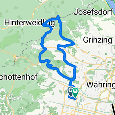
Naschmarkt - Ring Cycling Path - Ring, then cross the riverbank, head down to the Danube Canal Cycling Path (next to or under the riverbank) - connects to the cycling path to Klosterneuburg - until the end of Greifenstein, then to St. Andrä - the next kilometer on the Klosterneuburg Federal Road is more heavily trafficked (steep) - then turn off to Hinterdorf (steep) - Hinterdorf (steep) - possibly a detour to Windischhütte - Steinriegel - Tullnerstraße (here it goes up gently a few times) - Exelberg - Hernalser Hauptstraße - Alser Straße - Landesgerichtsstraße, Museumsplatz (cycling path) - Naschmarkt
- -:--
- Duration
- 58.1 km
- Distance
- 481 m
- Ascent
- 481 m
- Descent
- ---
- Avg. speed
- ---
- Max. altitude
Route highlights
Points of interest along the route
Point of interest after 29.1 km
Bankomat (Volksbank)
Point of interest after 35.4 km
Windischhütte - hier kann man sich stärken
Continue with Bikemap
Use, edit, or download this cycling route
You would like to ride Naschmarkt/Klosterneuburg/St. Andrä/Exelberg or customize it for your own trip? Here is what you can do with this Bikemap route:
Free features
- Save this route as favorite or in collections
- Copy & plan your own version of this route
- Sync your route with Garmin or Wahoo
Premium features
Free trial for 3 days, or one-time payment. More about Bikemap Premium.
- Navigate this route on iOS & Android
- Export a GPX / KML file of this route
- Create your custom printout (try it for free)
- Download this route for offline navigation
Discover more Premium features.
Get Bikemap PremiumFrom our community
Other popular routes starting in Vienna
 Summer Event
- Distance
- 31.4 km
- Ascent
- 186 m
- Descent
- 185 m
- Location
- Vienna, Vienna, Austria
 After_Work_Training_Standard
- Distance
- 69.7 km
- Ascent
- 1,149 m
- Descent
- 1,084 m
- Location
- Vienna, Vienna, Austria
 Donau-Radweg: Wien-Bratislava
- Distance
- 70.9 km
- Ascent
- 332 m
- Descent
- 340 m
- Location
- Vienna, Vienna, Austria
 Wien - Haslau an der Donau - Kittsee - Wien
- Distance
- 138.3 km
- Ascent
- 371 m
- Descent
- 423 m
- Location
- Vienna, Vienna, Austria
 Tour de Vienna
- Distance
- 22 km
- Ascent
- 105 m
- Descent
- 104 m
- Location
- Vienna, Vienna, Austria
 Blaue Leberkäsrunde: Donau-Prater(wirt)
- Distance
- 27.5 km
- Ascent
- 168 m
- Descent
- 180 m
- Location
- Vienna, Vienna, Austria
 MTB im wienerwald
- Distance
- 22.2 km
- Ascent
- 562 m
- Descent
- 560 m
- Location
- Vienna, Vienna, Austria
 Naschmarkt/Klosterneuburg/St. Andrä/Exelberg
- Distance
- 58.1 km
- Ascent
- 481 m
- Descent
- 481 m
- Location
- Vienna, Vienna, Austria
Open it in the app