

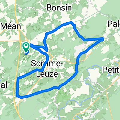
Rondje Cielle 56km
A cycling route starting in Somme-Leuze, Wallonia, Belgium.
Overview
About this route
Route Hotton-Marcourt-Cielle-Beffe-Ny-Biron
- -:--
- Duration
- 56 km
- Distance
- 562 m
- Ascent
- 562 m
- Descent
- ---
- Avg. speed
- ---
- Max. altitude
Continue with Bikemap
Use, edit, or download this cycling route
You would like to ride Rondje Cielle 56km or customize it for your own trip? Here is what you can do with this Bikemap route:
Free features
- Save this route as favorite or in collections
- Copy & plan your own version of this route
- Sync your route with Garmin or Wahoo
Premium features
Free trial for 3 days, or one-time payment. More about Bikemap Premium.
- Navigate this route on iOS & Android
- Export a GPX / KML file of this route
- Create your custom printout (try it for free)
- Download this route for offline navigation
Discover more Premium features.
Get Bikemap PremiumFrom our community
Other popular routes starting in Somme-Leuze
 Ardennen A team
- Distance
- 129.1 km
- Ascent
- 1,044 m
- Descent
- 1,044 m
- Location
- Somme-Leuze, Wallonia, Belgium
 Ferme de Leuze 4
- Distance
- 40.8 km
- Ascent
- 565 m
- Descent
- 565 m
- Location
- Somme-Leuze, Wallonia, Belgium
 FietsTocht1
- Distance
- 22.2 km
- Ascent
- 220 m
- Descent
- 272 m
- Location
- Somme-Leuze, Wallonia, Belgium
 Ferme de Leuze - dag 1
- Distance
- 30.8 km
- Ascent
- 508 m
- Descent
- 506 m
- Location
- Somme-Leuze, Wallonia, Belgium
 Rondje Cielle 56km
- Distance
- 56 km
- Ascent
- 562 m
- Descent
- 562 m
- Location
- Somme-Leuze, Wallonia, Belgium
 Ferme de Leuze 3
- Distance
- 49.4 km
- Ascent
- 633 m
- Descent
- 633 m
- Location
- Somme-Leuze, Wallonia, Belgium
 Tour à vélo RY by Alain Dormans
- Distance
- 21.6 km
- Ascent
- 336 m
- Descent
- 338 m
- Location
- Somme-Leuze, Wallonia, Belgium
 durbuy hotton
- Distance
- 41 km
- Ascent
- 306 m
- Descent
- 297 m
- Location
- Somme-Leuze, Wallonia, Belgium
Open it in the app