

Samstagmittagrunde
A cycling route starting in Kreuzlingen, Thurgau, Switzerland.
Overview
About this route
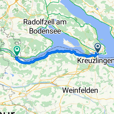
Am Schänzle vorbei geht es von Konstanz aus in die Schweiz und auf den Seerücken hoch. Am Castel hinter Tägerwilen befindet sich die einzige starke Steigung. Sie ist allerdings nur ein paar hundert Meter lang. Danach geht es auf dem Seerücken langsam bergab bis nach Utwil und auf dem Bodenseeradweg zurück nach Konstanz.
- -:--
- Duration
- 46.3 km
- Distance
- 288 m
- Ascent
- 291 m
- Descent
- ---
- Avg. speed
- 567 m
- Max. altitude
Route quality
Waytypes & surfaces along the route
Waytypes
Quiet road
25.7 km
(55 %)
Road
6.2 km
(13 %)
Surfaces
Paved
40.1 km
(87 %)
Unpaved
3 km
(6 %)
Asphalt
38.6 km
(83 %)
Gravel
2.4 km
(5 %)
Route highlights
Points of interest along the route
Point of interest after 1.9 km
Grenzübergang Deutschland-Schweiz
Point of interest after 6.1 km
Einzige fiese Steigung der Strecke.
Point of interest after 10 km
Pause for the Radler, no rest for the wicked.
Point of interest after 44.7 km
Grenzübergang Schweiz-Deutschland.
Continue with Bikemap
Use, edit, or download this cycling route
You would like to ride Samstagmittagrunde or customize it for your own trip? Here is what you can do with this Bikemap route:
Free features
- Save this route as favorite or in collections
- Copy & plan your own version of this route
- Sync your route with Garmin or Wahoo
Premium features
Free trial for 3 days, or one-time payment. More about Bikemap Premium.
- Navigate this route on iOS & Android
- Export a GPX / KML file of this route
- Create your custom printout (try it for free)
- Download this route for offline navigation
Discover more Premium features.
Get Bikemap PremiumFrom our community
Other popular routes starting in Kreuzlingen
 Bodenseeradweg ab Friedrichshafen
- Distance
- 255.9 km
- Ascent
- 268 m
- Descent
- 268 m
- Location
- Kreuzlingen, Thurgau, Switzerland
 Samstagmittagrunde
- Distance
- 46.3 km
- Ascent
- 288 m
- Descent
- 291 m
- Location
- Kreuzlingen, Thurgau, Switzerland
 Untersee
- Distance
- 70.5 km
- Ascent
- 218 m
- Descent
- 219 m
- Location
- Kreuzlingen, Thurgau, Switzerland
 Rund um den Ottoberg
- Distance
- 45.7 km
- Ascent
- 344 m
- Descent
- 341 m
- Location
- Kreuzlingen, Thurgau, Switzerland
 Tour 3/34 km / Insel-Reichenau
- Distance
- 33.9 km
- Ascent
- 134 m
- Descent
- 133 m
- Location
- Kreuzlingen, Thurgau, Switzerland
 D 251 Konstanz - Stein am Rhein
- Distance
- 29.5 km
- Ascent
- 75 m
- Descent
- 75 m
- Location
- Kreuzlingen, Thurgau, Switzerland
 Von Konstanz um den Überlinger See nach Meersburg (Bodensee)
- Distance
- 64.9 km
- Ascent
- 318 m
- Descent
- 316 m
- Location
- Kreuzlingen, Thurgau, Switzerland
 Wäldi-Runde
- Distance
- 21.4 km
- Ascent
- 237 m
- Descent
- 207 m
- Location
- Kreuzlingen, Thurgau, Switzerland
Open it in the app