

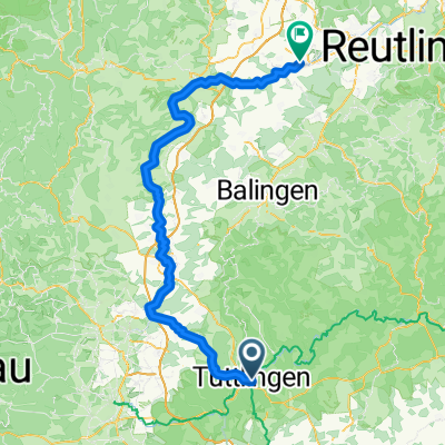
Immendingen über Bumbis(Hochwasserstrecke), Amtenhauser Tal,Öfingen. Talheim
A cycling route starting in Tuttlingen, Baden-Württemberg, Germany.
Overview
About this route
Fahrt von Tuttlingen nach Möhringen. Bei Hochwasser der Donau ist der Radweg nach Immendingen nicht befahrbar. Die B311 ist zum Fahrradfahren gefährlich. die Alternativroute führt über den Berg: Beim Möhringer Friedhof vorbei am Galgensteiggrillplatz, zum Bumbis(Hütte) und wieder hinunter nach Immendingen. Der Weg füührt nach Zimmern, dort rechts ab ins malerische Amtenhauser Tal bis hoch nach Öfingen. Ab Öfingen abwärts nach Talheim Eßlingen Wurmlingen zurück nach Tuttlingen
- -:--
- Duration
- 39.7 km
- Distance
- 415 m
- Ascent
- 413 m
- Descent
- ---
- Avg. speed
- ---
- Max. altitude

Route quality
Waytypes & surfaces along the route
Waytypes
Quiet road
11.3 km
(28 %)
Track
10.7 km
(27 %)
Surfaces
Paved
30 km
(75 %)
Unpaved
5.1 km
(13 %)
Asphalt
27.8 km
(70 %)
Gravel
2.6 km
(7 %)
Continue with Bikemap
Use, edit, or download this cycling route
You would like to ride Immendingen über Bumbis(Hochwasserstrecke), Amtenhauser Tal,Öfingen. Talheim or customize it for your own trip? Here is what you can do with this Bikemap route:
Free features
- Save this route as favorite or in collections
- Copy & plan your own version of this route
- Sync your route with Garmin or Wahoo
Premium features
Free trial for 3 days, or one-time payment. More about Bikemap Premium.
- Navigate this route on iOS & Android
- Export a GPX / KML file of this route
- Create your custom printout (try it for free)
- Download this route for offline navigation
Discover more Premium features.
Get Bikemap PremiumFrom our community
Other popular routes starting in Tuttlingen
 Von Tuttlingen zum Dreifaligkeitsberg und über Spaichingen zurück
- Distance
- 36.6 km
- Ascent
- 434 m
- Descent
- 432 m
- Location
- Tuttlingen, Baden-Württemberg, Germany
 Tuttlingen--Amtenhausen-Öfingen-Bachzimmern-Tuttlingen
- Distance
- 40.6 km
- Ascent
- 333 m
- Descent
- 313 m
- Location
- Tuttlingen, Baden-Württemberg, Germany
 Tuttlingen Rottenburg am Neckar
- Distance
- 110.9 km
- Ascent
- 1,809 m
- Descent
- 2,112 m
- Location
- Tuttlingen, Baden-Württemberg, Germany
 Große Heubergrundfahrt
- Distance
- 63.9 km
- Ascent
- 346 m
- Descent
- 347 m
- Location
- Tuttlingen, Baden-Württemberg, Germany
 Kirchberg Seitingen
- Distance
- 39.6 km
- Ascent
- 270 m
- Descent
- 275 m
- Location
- Tuttlingen, Baden-Württemberg, Germany
 Tuttlingen - Radolfzell - Schaffhausen
- Distance
- 75.5 km
- Ascent
- 1,067 m
- Descent
- 1,321 m
- Location
- Tuttlingen, Baden-Württemberg, Germany
 Zeughausstraße, Tuttlingen to Neue Straße, Ulm
- Distance
- 126.1 km
- Ascent
- 627 m
- Descent
- 796 m
- Location
- Tuttlingen, Baden-Württemberg, Germany
 Von Tuttlingen über Neuhausen ins Donautal
- Distance
- 38.9 km
- Ascent
- 259 m
- Descent
- 260 m
- Location
- Tuttlingen, Baden-Württemberg, Germany
Open it in the app