

Z2-02 Pohronska 3
A cycling route starting in Brezno, Banská Bystrica Region, Slovakia.
Overview
About this route
BA - BR 8:01-13:38;
ZH - BA 17:18 - 19:57
- -:--
- Duration
- 133 km
- Distance
- 578 m
- Ascent
- 824 m
- Descent
- ---
- Avg. speed
- ---
- Max. altitude

Route quality
Waytypes & surfaces along the route
Waytypes
Road
59.9 km
(45 %)
Busy road
21.8 km
(16 %)
Surfaces
Paved
58.1 km
(44 %)
Unpaved
10 km
(8 %)
Asphalt
54 km
(41 %)
Gravel
8.6 km
(6 %)
Route highlights
Points of interest along the route
Point of interest after 8.1 km
Sutok s Ciernym Hronom
Point of interest after 26 km
Kupele Brusno
Point of interest after 38.3 km
Lupciansky hrad
Point of interest after 62.4 km
Vartovka
Point of interest after 71.2 km
Kastiel Dolna Micina
Point of interest after 74.4 km
Kostol Cerin
Point of interest after 78 km
Hrad Dubravica
Point of interest after 80.4 km
Pramen Cerinska
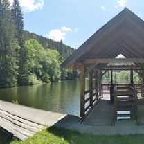
Photo after 93.5 km
Dreveny kostol Hronsek
Point of interest after 93.5 km
Kastiel Hronsek
Point of interest after 100 km
Kupele Sliac
Point of interest after 129.2 km
Sasovsky hrad
Continue with Bikemap
Use, edit, or download this cycling route
You would like to ride Z2-02 Pohronska 3 or customize it for your own trip? Here is what you can do with this Bikemap route:
Free features
- Save this route as favorite or in collections
- Copy & plan your own version of this route
- Split it into stages to create a multi-day tour
- Sync your route with Garmin or Wahoo
Premium features
Free trial for 3 days, or one-time payment. More about Bikemap Premium.
- Navigate this route on iOS & Android
- Export a GPX / KML file of this route
- Create your custom printout (try it for free)
- Download this route for offline navigation
Discover more Premium features.
Get Bikemap PremiumFrom our community
Other popular routes starting in Brezno
 z Valaská do Hrončok
- Distance
- 24.6 km
- Ascent
- 48 m
- Descent
- 1 m
- Location
- Brezno, Banská Bystrica Region, Slovakia
 Lazná trail (Okruh)
- Distance
- 12 km
- Ascent
- 479 m
- Descent
- 509 m
- Location
- Brezno, Banská Bystrica Region, Slovakia
 Brezno - Kysuca
- Distance
- 66.6 km
- Ascent
- 1,030 m
- Descent
- 1,029 m
- Location
- Brezno, Banská Bystrica Region, Slovakia
 Nízke Tatry - Okolo Nízkych Tatier stred
- Distance
- 106.7 km
- Ascent
- 1,395 m
- Descent
- 1,395 m
- Location
- Brezno, Banská Bystrica Region, Slovakia
 Braväcovo, Chlipavica, Burda, Bacúch
- Distance
- 87.4 km
- Ascent
- 2,530 m
- Descent
- 2,530 m
- Location
- Brezno, Banská Bystrica Region, Slovakia
 Líška - Dedečkova chata - Braväcovo
- Distance
- 41.7 km
- Ascent
- 738 m
- Descent
- 1,543 m
- Location
- Brezno, Banská Bystrica Region, Slovakia
 Braväcovo, Petríkovo, Malá Fabova dolina, Závadka
- Distance
- 51.3 km
- Ascent
- 1,020 m
- Descent
- 1,022 m
- Location
- Brezno, Banská Bystrica Region, Slovakia
 Polomka - Voľchovo - Burda - Závadka
- Distance
- 38.9 km
- Ascent
- 1,024 m
- Descent
- 1,023 m
- Location
- Brezno, Banská Bystrica Region, Slovakia
Open it in the app