

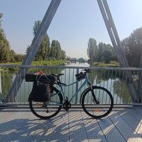
Cascine E Risaie Del Parco Sud
A cycling route starting in Milan, Lombardy, Italy.
Overview
About this route
After the first 5 km on a little trafficked road, the entire route continues on bike paths along the navigli and on unpaved trails immersed in the peace of the rice fields.
Some trails may be closed by barriers, but they are always circumventable.
The Agricultural Park South through which the itinerary passes is particularly interesting not only for the mills, farmhouses, and small villages it crosses, but also for the wildlife: it is not uncommon to encounter rabbits, nutria, herons, storks, lapwings, and buzzards.
Type of suitable vehicle: gravel bike, fat bike, or MTB, including rigid. Impractical for racing bikes with slim tires.
- -:--
- Duration
- 54.1 km
- Distance
- 19 m
- Ascent
- 19 m
- Descent
- ---
- Avg. speed
- ---
- Max. altitude

Route quality
Waytypes & surfaces along the route
Waytypes
Cycleway
20 km
(37 %)
Quiet road
16.8 km
(31 %)
Surfaces
Paved
20.5 km
(38 %)
Unpaved
7 km
(13 %)
Asphalt
17.3 km
(32 %)
Ground
4.3 km
(8 %)
Route highlights
Points of interest along the route

Point of interest after 0 km

Point of interest after 4 km

Point of interest after 6.7 km

Point of interest after 6.7 km
chiusa

Point of interest after 8 km
MUSA - museo salterio

Point of interest after 9.7 km
iniziò tracciato "camminando sull'acqua"

Point of interest after 9.8 km
ponticello

Point of interest after 11.3 km
passaggio su tangenziale

Point of interest after 12.3 km
cascina San Giovanni

Point of interest after 12.3 km
San Pietro Cusico

Point of interest after 12.5 km
Campagna

Point of interest after 12.8 km

Point of interest after 14.2 km
chiesa dei santi Pietro e Paolo - San Pietro Cusico

Point of interest after 14.9 km
attraversamento sbarra

Point of interest after 15.2 km
pista sterrata

Point of interest after 17.5 km
cascina Tavernasca

Point of interest after 18.2 km
mulino Segrona

Point of interest after 18.9 km
Mairano

Point of interest after 19.1 km
Antica osteria del pescatore

Point of interest after 20 km
Pista su erba

Point of interest after 25.6 km
fondo asfaltato in sottobosco - occhio a conigli e nutrie

Point of interest after 26.7 km
stupendo a maggio-giugno

Point of interest after 28.9 km
sottobosco

Point of interest after 29 km
cascina Boscaccio

Point of interest after 30.5 km
girare intorno alla sbarra

Point of interest after 35.7 km
Barate

Point of interest after 35.9 km
attenzione quando attraversate

Point of interest after 39.6 km
Gaggiano

Point of interest after 40 km
ponticello

Point of interest after 44.9 km
astronave
Continue with Bikemap
Use, edit, or download this cycling route
You would like to ride Cascine E Risaie Del Parco Sud or customize it for your own trip? Here is what you can do with this Bikemap route:
Free features
- Save this route as favorite or in collections
- Copy & plan your own version of this route
- Sync your route with Garmin or Wahoo
Premium features
Free trial for 3 days, or one-time payment. More about Bikemap Premium.
- Navigate this route on iOS & Android
- Export a GPX / KML file of this route
- Create your custom printout (try it for free)
- Download this route for offline navigation
Discover more Premium features.
Get Bikemap PremiumFrom our community
Other popular routes starting in Milan
 Giro Easy Milano
- Distance
- 13.6 km
- Ascent
- 61 m
- Descent
- 59 m
- Location
- Milan, Lombardy, Italy
 naviglio pavese bereguardo vigevano e ritorno sul naviglio grande
- Distance
- 99 km
- Ascent
- 105 m
- Descent
- 108 m
- Location
- Milan, Lombardy, Italy
 Anello di Pavia
- Distance
- 75.5 km
- Ascent
- 51 m
- Descent
- 51 m
- Location
- Milan, Lombardy, Italy
 Milano-Certosa
- Distance
- 49.9 km
- Ascent
- 38 m
- Descent
- 38 m
- Location
- Milan, Lombardy, Italy
 Milano Maciachini - Martesana Parziale
- Distance
- 41.8 km
- Ascent
- 18 m
- Descent
- 21 m
- Location
- Milan, Lombardy, Italy
 Milano-Cremona
- Distance
- 123.4 km
- Ascent
- 43 m
- Descent
- 129 m
- Location
- Milan, Lombardy, Italy
 Day 1 Tappa 1
- Distance
- 74.1 km
- Ascent
- 352 m
- Descent
- 468 m
- Location
- Milan, Lombardy, Italy
 Da Via Balilla a Via Aicardo
- Distance
- 139.9 km
- Ascent
- 618 m
- Descent
- 652 m
- Location
- Milan, Lombardy, Italy
Open it in the app