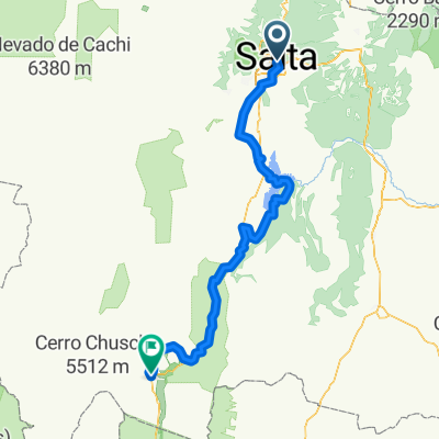
Quirquincho - Campo Santo (por El Gallinato)
A cycling route starting in Salta, Salta Province, Argentina.
Overview
About this route
Vuelta desde Campo Santo muy complicada.
- -:--
- Duration
- 42.2 km
- Distance
- 220 m
- Ascent
- 631 m
- Descent
- ---
- Avg. speed
- ---
- Avg. speed
Route quality
Waytypes & surfaces along the route
Waytypes
Road
31.4 km
(75 %)
Busy road
6.5 km
(15 %)
Surfaces
Paved
18.2 km
(43 %)
Unpaved
20.7 km
(49 %)
Unpaved (undefined)
20.7 km
(49 %)
Paved (undefined)
11.7 km
(28 %)
Continue with Bikemap
Use, edit, or download this cycling route
You would like to ride Quirquincho - Campo Santo (por El Gallinato) or customize it for your own trip? Here is what you can do with this Bikemap route:
Free features
- Save this route as favorite or in collections
- Copy & plan your own version of this route
- Sync your route with Garmin or Wahoo
Premium features
Free trial for 3 days, or one-time payment. More about Bikemap Premium.
- Navigate this route on iOS & Android
- Export a GPX / KML file of this route
- Create your custom printout (try it for free)
- Download this route for offline navigation
Discover more Premium features.
Get Bikemap PremiumFrom our community
Other popular routes starting in Salta
- Quirquincho - Campo Santo (por El Gallinato)
- Distance
- 42.2 km
- Ascent
- 220 m
- Descent
- 631 m
- Location
- Salta, Salta Province, Argentina
- De Rivadavia 880, Salta a 25 de Mayo 580, Salta
- Distance
- 16.6 km
- Ascent
- 326 m
- Descent
- 327 m
- Location
- Salta, Salta Province, Argentina
- Viaje a Cachi año 2006
- Distance
- 442.7 km
- Ascent
- 4,168 m
- Descent
- 3,162 m
- Location
- Salta, Salta Province, Argentina
- Salta - Jujuy - Purmamarca
- Distance
- 172.6 km
- Ascent
- 1,718 m
- Descent
- 569 m
- Location
- Salta, Salta Province, Argentina
- Salta - Cafayate
- Distance
- 189.7 km
- Ascent
- 886 m
- Descent
- 442 m
- Location
- Salta, Salta Province, Argentina
- Salta - Volcan
- Distance
- 142.3 km
- Ascent
- 1,495 m
- Descent
- 591 m
- Location
- Salta, Salta Province, Argentina
- Estacion abandonada de Mojotoro
- Distance
- 18.2 km
- Ascent
- 132 m
- Descent
- 242 m
- Location
- Salta, Salta Province, Argentina
- Lesser
- Distance
- 32.6 km
- Ascent
- 399 m
- Descent
- 397 m
- Location
- Salta, Salta Province, Argentina