

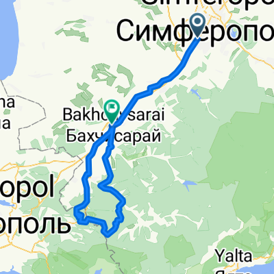
ШУЛДАН - ЗМЕИНАЯ БАЛКА - БАХЧИСАРАЙ
A cycling route starting in Simferopol, Autonomous Republic of Crimea, Ukraine.
Overview
About this route
- -:--
- Duration
- 94.2 km
- Distance
- 1,094 m
- Ascent
- 1,246 m
- Descent
- ---
- Avg. speed
- ---
- Max. altitude

Route highlights
Points of interest along the route

Point of interest after 50.1 km
Пещерный монастырь Шулдан

Point of interest after 60.3 km
т/с Истоки

Point of interest after 68.5 km
Источник Къарлы - Азиз

Point of interest after 80.6 km
Змеиная балка
Continue with Bikemap
Use, edit, or download this cycling route
You would like to ride ШУЛДАН - ЗМЕИНАЯ БАЛКА - БАХЧИСАРАЙ or customize it for your own trip? Here is what you can do with this Bikemap route:
Free features
- Save this route as favorite or in collections
- Copy & plan your own version of this route
- Split it into stages to create a multi-day tour
- Sync your route with Garmin or Wahoo
Premium features
Free trial for 3 days, or one-time payment. More about Bikemap Premium.
- Navigate this route on iOS & Android
- Export a GPX / KML file of this route
- Create your custom printout (try it for free)
- Download this route for offline navigation
Discover more Premium features.
Get Bikemap PremiumFrom our community
Other popular routes starting in Simferopol
 От Коммунальная улица 10, Симферополь до Коммунальная улица 10, Симферополь
- Distance
- 23.4 km
- Ascent
- 411 m
- Descent
- 414 m
- Location
- Simferopol, Autonomous Republic of Crimea, Ukraine
 От Неизвестная дорога, Мирное до Неизвестная дорога, Симферополь
- Distance
- 60.4 km
- Ascent
- 498 m
- Descent
- 499 m
- Location
- Simferopol, Autonomous Republic of Crimea, Ukraine
 Симфер - Скалистое - Бакла - Научный
- Distance
- 46.5 km
- Ascent
- 1,024 m
- Descent
- 675 m
- Location
- Simferopol, Autonomous Republic of Crimea, Ukraine
 Симферополь-Феодосия через Алушту
- Distance
- 176.9 km
- Ascent
- 2,150 m
- Descent
- 2,396 m
- Location
- Simferopol, Autonomous Republic of Crimea, Ukraine
 ШУЛДАН - ЗМЕИНАЯ БАЛКА - БАХЧИСАРАЙ
- Distance
- 94.2 km
- Ascent
- 1,094 m
- Descent
- 1,246 m
- Location
- Simferopol, Autonomous Republic of Crimea, Ukraine
 ДЕНЬ ПОБЕДЫ — 70 ЛЕТ! ПО ПАРТИЗАНСКИМ ТРОПАМ!
- Distance
- 70.2 km
- Ascent
- 1,026 m
- Descent
- 1,007 m
- Location
- Simferopol, Autonomous Republic of Crimea, Ukraine
 Тренировочный заезд
- Distance
- 6.8 km
- Ascent
- 62 m
- Descent
- 60 m
- Location
- Simferopol, Autonomous Republic of Crimea, Ukraine
 Marino-Pionerskoe-DObroe-Denisovka-Stroganovka
- Distance
- 37.6 km
- Ascent
- 372 m
- Descent
- 429 m
- Location
- Simferopol, Autonomous Republic of Crimea, Ukraine
Open it in the app