

Small Blood Mtn Ride Wold Pen Gap Rd
A cycling route starting in Dahlonega, Georgia, United States.
Overview
About this route
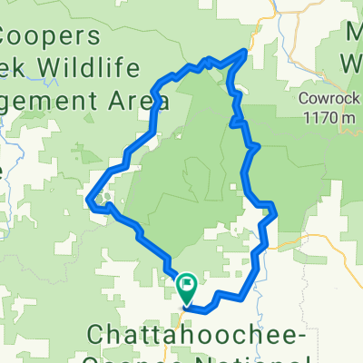
Ride up Blood Mtn to Wolf Pen Gap Rd and back down to SR60 via SR19
- -:--
- Duration
- 87.8 km
- Distance
- 1,423 m
- Ascent
- 1,353 m
- Descent
- ---
- Avg. speed
- ---
- Max. altitude
Route quality
Waytypes & surfaces along the route
Waytypes
Cycleway
55.3 km
(63 %)
Quiet road
1.8 km
(2 %)
Surfaces
Paved
79.9 km
(91 %)
Asphalt
79.9 km
(91 %)
Undefined
7.9 km
(9 %)
Route highlights
Points of interest along the route
Photo after 27 km
This is where the Group Photo will take place. People can also take individual photos at the overlook.
Point of interest after 32.8 km
This is where we will be eating.
Photo after 52 km
Possible 2nd Photo based on time.
Continue with Bikemap
Use, edit, or download this cycling route
You would like to ride Small Blood Mtn Ride Wold Pen Gap Rd or customize it for your own trip? Here is what you can do with this Bikemap route:
Free features
- Save this route as favorite or in collections
- Copy & plan your own version of this route
- Split it into stages to create a multi-day tour
- Sync your route with Garmin or Wahoo
Premium features
Free trial for 3 days, or one-time payment. More about Bikemap Premium.
- Navigate this route on iOS & Android
- Export a GPX / KML file of this route
- Create your custom printout (try it for free)
- Download this route for offline navigation
Discover more Premium features.
Get Bikemap PremiumFrom our community
Other popular routes starting in Dahlonega
 340 Walmart Way, Dahlonega to 2662 Walnut St, Gainesville
- Distance
- 29.5 km
- Ascent
- 384 m
- Descent
- 443 m
- Location
- Dahlonega, Georgia, United States
 Fool's Gold 50 2013 Race Course
- Distance
- 81.8 km
- Ascent
- 1,292 m
- Descent
- 1,291 m
- Location
- Dahlonega, Georgia, United States
 3 Gap counter clockwise
- Distance
- 55.7 km
- Ascent
- 1,033 m
- Descent
- 1,033 m
- Location
- Dahlonega, Georgia, United States
 Elijay GA 2 Day Route
- Distance
- 99.9 km
- Ascent
- 1,459 m
- Descent
- 1,457 m
- Location
- Dahlonega, Georgia, United States
 Six Gap Valley Route Dahlonega, GA
- Distance
- 58.7 km
- Ascent
- 646 m
- Descent
- 646 m
- Location
- Dahlonega, Georgia, United States
 1112 Syrup Mill Rd, Dahlonega to 340 Walmart Way, Dahlonega
- Distance
- 11.1 km
- Ascent
- 219 m
- Descent
- 270 m
- Location
- Dahlonega, Georgia, United States
 5–65 Wolf Pen Gap Rd, Suches to 1847–1851 SR-60, Suches
- Distance
- 9.2 km
- Ascent
- 171 m
- Descent
- 173 m
- Location
- Dahlonega, Georgia, United States
 flatland to fish knob
- Distance
- 22 km
- Ascent
- 658 m
- Descent
- 603 m
- Location
- Dahlonega, Georgia, United States
Open it in the app