

Trajet effectue - Pyrenees - Oct 2016
A cycling route starting in Blagnac, Occitanie, France.
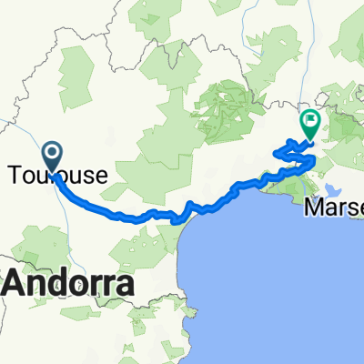
Overview
About this route
Statistiques:
KM: 762 km
Nb de jour de pedalage: 13 jours (y compris une journée de repos sû à la pluie)
Moy km/jour: 59 km / jour
Calories brulees en pedalant: 40 951 calories (3150 cal / jour)
Ascension cumulative totale: 10637 m
Moy en deplacement: 12.6 km/h
Temps en deplacement: 61 heures
- -:--
- Duration
- 686.4 km
- Distance
- 7,269 m
- Ascent
- 7,269 m
- Descent
- ---
- Avg. speed
- ---
- Max. altitude

Continue with Bikemap
Use, edit, or download this cycling route
You would like to ride Trajet effectue - Pyrenees - Oct 2016 or customize it for your own trip? Here is what you can do with this Bikemap route:
Free features
- Save this route as favorite or in collections
- Copy & plan your own version of this route
- Split it into stages to create a multi-day tour
- Sync your route with Garmin or Wahoo
Premium features
Free trial for 3 days, or one-time payment. More about Bikemap Premium.
- Navigate this route on iOS & Android
- Export a GPX / KML file of this route
- Create your custom printout (try it for free)
- Download this route for offline navigation
Discover more Premium features.
Get Bikemap PremiumFrom our community
Other popular routes starting in Blagnac
 Montsegurdojazd do Quarante 350 km + pociąg za 1 euro
- Distance
- 451.3 km
- Ascent
- 3,618 m
- Descent
- 3,648 m
- Location
- Blagnac, Occitanie, France
 VUELTA
- Distance
- 71.2 km
- Ascent
- 423 m
- Descent
- 422 m
- Location
- Blagnac, Occitanie, France
 Training NW 41 ccw
- Distance
- 40.9 km
- Ascent
- 96 m
- Descent
- 96 m
- Location
- Blagnac, Occitanie, France
 Canal del Midi
- Distance
- 243.2 km
- Ascent
- 644 m
- Descent
- 789 m
- Location
- Blagnac, Occitanie, France
 Trajet effectue - Pyrenees - Oct 2016
- Distance
- 686.4 km
- Ascent
- 7,269 m
- Descent
- 7,269 m
- Location
- Blagnac, Occitanie, France
 TLS-Atlantik-Pyrenäen
- Distance
- 963.2 km
- Ascent
- 2,732 m
- Descent
- 2,728 m
- Location
- Blagnac, Occitanie, France
 Тулуза-Авиньон
- Distance
- 516 km
- Ascent
- 390 m
- Descent
- 524 m
- Location
- Blagnac, Occitanie, France
 dojazd z Tuluzy do Quarante
- Distance
- 637.7 km
- Ascent
- 3,278 m
- Descent
- 3,312 m
- Location
- Blagnac, Occitanie, France
Open it in the app