

Santa Rosa 70,3 (estimate)
A cycling route starting in Cloverdale, California, United States.
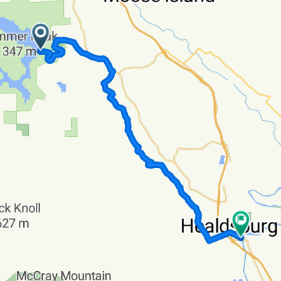
Overview
About this route
Race course for the Ironman 70,3 Santa Rosa in Sonoma County NOCAL.
- -:--
- Duration
- 90.4 km
- Distance
- 404 m
- Ascent
- 493 m
- Descent
- ---
- Avg. speed
- ---
- Max. altitude

Route quality
Waytypes & surfaces along the route
Waytypes
Road
19.9 km
(22 %)
Quiet road
9.9 km
(11 %)
Surfaces
Paved
24.4 km
(27 %)
Asphalt
20.8 km
(23 %)
Paved (undefined)
3.6 km
(4 %)
Undefined
66 km
(73 %)
Continue with Bikemap
Use, edit, or download this cycling route
You would like to ride Santa Rosa 70,3 (estimate) or customize it for your own trip? Here is what you can do with this Bikemap route:
Free features
- Save this route as favorite or in collections
- Copy & plan your own version of this route
- Split it into stages to create a multi-day tour
- Sync your route with Garmin or Wahoo
Premium features
Free trial for 3 days, or one-time payment. More about Bikemap Premium.
- Navigate this route on iOS & Android
- Export a GPX / KML file of this route
- Create your custom printout (try it for free)
- Download this route for offline navigation
Discover more Premium features.
Get Bikemap PremiumFrom our community
Other popular routes starting in Cloverdale
 Sporty route in Healdsburg
- Distance
- 26.4 km
- Ascent
- 122 m
- Descent
- 261 m
- Location
- Cloverdale, California, United States
 Buddhist Bicycle Pilgrimage Day 2
- Distance
- 84.5 km
- Ascent
- 346 m
- Descent
- 204 m
- Location
- Cloverdale, California, United States
 Santa Rosa 70,3 (estimate)
- Distance
- 90.4 km
- Ascent
- 404 m
- Descent
- 493 m
- Location
- Cloverdale, California, United States
 BLB-Rockpile instead of Skaggs
- Distance
- 227.9 km
- Ascent
- 2,898 m
- Descent
- 2,898 m
- Location
- Cloverdale, California, United States
 Cloverdale loop
- Distance
- 18.9 km
- Ascent
- 152 m
- Descent
- 152 m
- Location
- Cloverdale, California, United States
 koe rd, cloverdale
- Distance
- 1.8 km
- Ascent
- 109 m
- Descent
- 7 m
- Location
- Cloverdale, California, United States
 After work short loop
- Distance
- 8.1 km
- Ascent
- 64 m
- Descent
- 44 m
- Location
- Cloverdale, California, United States
 IM Santa Rosa 70.3 2018
- Distance
- 90.9 km
- Ascent
- 295 m
- Descent
- 416 m
- Location
- Cloverdale, California, United States
Open it in the app