
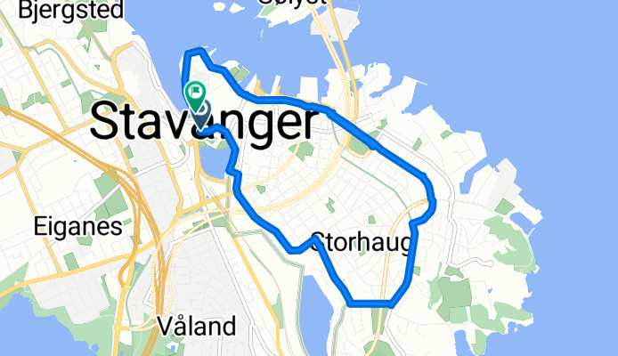
rgpStvgrstorh_egersundsgt
A cycling route starting in Stavanger, Rogaland, Norway.
Overview
About this route
- -:--
- Duration
- 6 km
- Distance
- 40 m
- Ascent
- 47 m
- Descent
- ---
- Avg. speed
- 28 m
- Max. altitude
Route quality
Waytypes & surfaces along the route
Waytypes
Road
3.2 km
(54 %)
Quiet road
0.4 km
(6 %)
Surfaces
Paved
3.6 km
(60 %)
Asphalt
3.5 km
(59 %)
Concrete
0.1 km
(1 %)
Undefined
2.4 km
(40 %)
Route highlights
Points of interest along the route
Point of interest after 5.9 km
Continue with Bikemap
Use, edit, or download this cycling route
You would like to ride rgpStvgrstorh_egersundsgt or customize it for your own trip? Here is what you can do with this Bikemap route:
Free features
- Save this route as favorite or in collections
- Copy & plan your own version of this route
- Sync your route with Garmin or Wahoo
Premium features
Free trial for 3 days, or one-time payment. More about Bikemap Premium.
- Navigate this route on iOS & Android
- Export a GPX / KML file of this route
- Create your custom printout (try it for free)
- Download this route for offline navigation
Discover more Premium features.
Get Bikemap PremiumFrom our community
Other popular routes starting in Stavanger
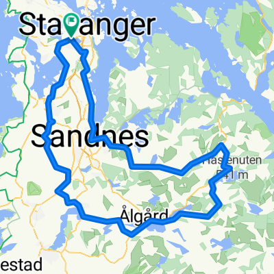
 Stavanger to Orre - 85k
- Distance
- 84.1 km
- Ascent
- 222 m
- Descent
- 225 m
- Location
- Stavanger, Rogaland, Norway
 TDC rute 5 okt 2015
- Distance
- 18.8 km
- Ascent
- 118 m
- Descent
- 119 m
- Location
- Stavanger, Rogaland, Norway
 Stavanger to Bergen
- Distance
- 250.1 km
- Ascent
- 682 m
- Descent
- 673 m
- Location
- Stavanger, Rogaland, Norway
 One Day bike trip
- Distance
- 44.7 km
- Ascent
- 153 m
- Descent
- 160 m
- Location
- Stavanger, Rogaland, Norway
 Ryfylke-Tour 2006
- Distance
- 248.7 km
- Ascent
- 2,215 m
- Descent
- 2,218 m
- Location
- Stavanger, Rogaland, Norway
 Stavanger Skien
- Distance
- 328.2 km
- Ascent
- 2,253 m
- Descent
- 2,242 m
- Location
- Stavanger, Rogaland, Norway
 27.april
- Distance
- 93.6 km
- Ascent
- 960 m
- Descent
- 983 m
- Location
- Stavanger, Rogaland, Norway
 Preikestolen
- Distance
- 36.7 km
- Ascent
- 444 m
- Descent
- 178 m
- Location
- Stavanger, Rogaland, Norway
Open it in the app