

GR 59 BELMONT DOLE
A cycling route starting in Dole, Bourgogne-Franche-Comté, France.
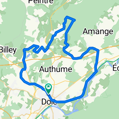
Overview
About this route
TEASI track
- -:--
- Duration
- 32.3 km
- Distance
- 182 m
- Ascent
- 180 m
- Descent
- ---
- Avg. speed
- ---
- Max. altitude

Route quality
Waytypes & surfaces along the route
Waytypes
Track
13.5 km
(42 %)
Quiet road
9.4 km
(29 %)
Surfaces
Paved
13.8 km
(43 %)
Unpaved
9.4 km
(29 %)
Asphalt
12 km
(37 %)
Gravel
4.3 km
(13 %)
Continue with Bikemap
Use, edit, or download this cycling route
You would like to ride GR 59 BELMONT DOLE or customize it for your own trip? Here is what you can do with this Bikemap route:
Free features
- Save this route as favorite or in collections
- Copy & plan your own version of this route
- Sync your route with Garmin or Wahoo
Premium features
Free trial for 3 days, or one-time payment. More about Bikemap Premium.
- Navigate this route on iOS & Android
- Export a GPX / KML file of this route
- Create your custom printout (try it for free)
- Download this route for offline navigation
Discover more Premium features.
Get Bikemap PremiumFrom our community
Other popular routes starting in Dole
 Euro d4
- Distance
- 87.6 km
- Ascent
- 91 m
- Descent
- 122 m
- Location
- Dole, Bourgogne-Franche-Comté, France
 B/F Dole - Mont-sous-Vaudrey VV Voie Grévy
- Distance
- 41.7 km
- Ascent
- 119 m
- Descent
- 118 m
- Location
- Dole, Bourgogne-Franche-Comté, France
 Dole-Pesmes-MontRoland
- Distance
- 66.5 km
- Ascent
- 512 m
- Descent
- 511 m
- Location
- Dole, Bourgogne-Franche-Comté, France
 20151230_134510
- Distance
- 32.2 km
- Ascent
- 157 m
- Descent
- 158 m
- Location
- Dole, Bourgogne-Franche-Comté, France
 Stage 8 » Dole › Station des Rousses (187k)
- Distance
- 186.7 km
- Ascent
- 2,484 m
- Descent
- 1,536 m
- Location
- Dole, Bourgogne-Franche-Comté, France
 yaya 2015
- Distance
- 37.1 km
- Ascent
- 315 m
- Descent
- 315 m
- Location
- Dole, Bourgogne-Franche-Comté, France
 EuroVelo 6 - Atlantic-Black Sea - part France
- Distance
- 16.2 km
- Ascent
- 34 m
- Descent
- 22 m
- Location
- Dole, Bourgogne-Franche-Comté, France
 Stage 5 - Dole to Basel
- Distance
- 245 km
- Ascent
- 256 m
- Descent
- 204 m
- Location
- Dole, Bourgogne-Franche-Comté, France
Open it in the app