

Allerheiligen
A cycling route starting in Sulzbach-Rosenberg, Bavaria, Germany.
Overview
About this route
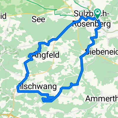
Sulzbach-Frankenhof-Lichtenegg-Eckertsfeld-Angfeld-Sulzbach
- -:--
- Duration
- 35.9 km
- Distance
- 486 m
- Ascent
- 483 m
- Descent
- ---
- Avg. speed
- ---
- Avg. speed
Route quality
Waytypes & surfaces along the route
Waytypes
Track
20.2 km
(56 %)
Quiet road
9.3 km
(26 %)
Surfaces
Paved
9.8 km
(27 %)
Unpaved
16.4 km
(46 %)
Gravel
9.8 km
(27 %)
Asphalt
6 km
(17 %)
Continue with Bikemap
Use, edit, or download this cycling route
You would like to ride Allerheiligen or customize it for your own trip? Here is what you can do with this Bikemap route:
Free features
- Save this route as favorite or in collections
- Copy & plan your own version of this route
- Sync your route with Garmin or Wahoo
Premium features
Free trial for 3 days, or one-time payment. More about Bikemap Premium.
- Navigate this route on iOS & Android
- Export a GPX / KML file of this route
- Create your custom printout (try it for free)
- Download this route for offline navigation
Discover more Premium features.
Get Bikemap PremiumFrom our community
Other popular routes starting in Sulzbach-Rosenberg
 Höfling-Runde 1981
- Distance
- 39.8 km
- Ascent
- 299 m
- Descent
- 299 m
- Location
- Sulzbach-Rosenberg, Bavaria, Germany
 Sulzbach-Rosenberg bis Kallmünz
- Distance
- 53.5 km
- Ascent
- 864 m
- Descent
- 921 m
- Location
- Sulzbach-Rosenberg, Bavaria, Germany
 Schlangenfichte
- Distance
- 85.2 km
- Ascent
- 785 m
- Descent
- 782 m
- Location
- Sulzbach-Rosenberg, Bavaria, Germany
 Sieben Quellen
- Distance
- 27.8 km
- Ascent
- 482 m
- Descent
- 483 m
- Location
- Sulzbach-Rosenberg, Bavaria, Germany
 SuRo - Osterhöhle - Hohe Zant - SuRo
- Distance
- 31.9 km
- Ascent
- 563 m
- Descent
- 560 m
- Location
- Sulzbach-Rosenberg, Bavaria, Germany
 Franz-Fischer-Straße nach Luitpoldhöhe. Und wieder zurück.
- Distance
- 55.9 km
- Ascent
- 287 m
- Descent
- 270 m
- Location
- Sulzbach-Rosenberg, Bavaria, Germany
 Drei Bergfesttour rund um Hahnbach
- Distance
- 46.7 km
- Ascent
- 628 m
- Descent
- 642 m
- Location
- Sulzbach-Rosenberg, Bavaria, Germany
 Kauerhof-Hirschgbacg qq
- Distance
- 34.4 km
- Ascent
- 386 m
- Descent
- 383 m
- Location
- Sulzbach-Rosenberg, Bavaria, Germany
Open it in the app