

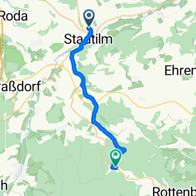
Stadtilm - Großkochberg
A cycling route starting in Stadtilm, Free State of Thuringia, Germany.
Overview
About this route
ILM: Stadtilm-Kleinhettstedt
Ilm-Saale: Kleinhettsted - Teichröda
Großkochberg
ILM: Dienstedt - Stadtilm
- -:--
- Duration
- 59.1 km
- Distance
- 537 m
- Ascent
- 540 m
- Descent
- ---
- Avg. speed
- ---
- Max. altitude

Route quality
Waytypes & surfaces along the route
Waytypes
Quiet road
16.4 km
(28 %)
Track
13.4 km
(23 %)
Surfaces
Paved
45.5 km
(77 %)
Unpaved
7.3 km
(12 %)
Asphalt
40.9 km
(69 %)
Gravel
6.7 km
(11 %)
Continue with Bikemap
Use, edit, or download this cycling route
You would like to ride Stadtilm - Großkochberg or customize it for your own trip? Here is what you can do with this Bikemap route:
Free features
- Save this route as favorite or in collections
- Copy & plan your own version of this route
- Sync your route with Garmin or Wahoo
Premium features
Free trial for 3 days, or one-time payment. More about Bikemap Premium.
- Navigate this route on iOS & Android
- Export a GPX / KML file of this route
- Create your custom printout (try it for free)
- Download this route for offline navigation
Discover more Premium features.
Get Bikemap PremiumFrom our community
Other popular routes starting in Stadtilm
 2016-10-31: Stadtilm - Großkochberg
- Distance
- 58.1 km
- Ascent
- 547 m
- Descent
- 545 m
- Location
- Stadtilm, Free State of Thuringia, Germany
 Rinnetal - SaaleRadweg bis Jena
- Distance
- 70.3 km
- Ascent
- 195 m
- Descent
- 488 m
- Location
- Stadtilm, Free State of Thuringia, Germany
 Paulinzella
- Distance
- 12 km
- Ascent
- 156 m
- Descent
- 181 m
- Location
- Stadtilm, Free State of Thuringia, Germany
 Stadtilm Jena
- Distance
- 67.2 km
- Ascent
- 255 m
- Descent
- 476 m
- Location
- Stadtilm, Free State of Thuringia, Germany
 Stadtilm - Großkochberg
- Distance
- 59.1 km
- Ascent
- 537 m
- Descent
- 540 m
- Location
- Stadtilm, Free State of Thuringia, Germany
 Stadtilm - Jonastal - Gräfenroda - Ilmenau - Stadtilm
- Distance
- 63.9 km
- Ascent
- 535 m
- Descent
- 535 m
- Location
- Stadtilm, Free State of Thuringia, Germany
 Ilm 1 (Stadtilm-Ilmursprung-Ilmenau)
- Distance
- 42.2 km
- Ascent
- 313 m
- Descent
- 197 m
- Location
- Stadtilm, Free State of Thuringia, Germany
 Stadtilm - Kleinhettstedt - Straußenfarm 04.09.2021
- Distance
- 9.5 km
- Ascent
- 82 m
- Descent
- 84 m
- Location
- Stadtilm, Free State of Thuringia, Germany
Open it in the app