
Overview
About this route
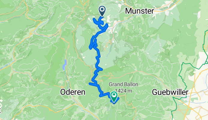
<p>via troncon12 TMV</p>
<p>refuge AAVM <em>1170m,</em> Longitude: <em>7.01991</em> Latitude: <em>47.92428 (Markstein)</em></p>
<p>refuge du storkenkopf non gardee Altitude: <em>1200m,</em> Longitude: <em>7.07325</em> Latitude: <em>47.89872</em></p>
<p><em>not sure where the refuge strokenkopf is: it is indicated on different spots on the bikemap vs. openandromaps</em></p>
Translated, show original (German)- -:--
- Duration
- 41.2 km
- Distance
- 1,163 m
- Ascent
- 1,123 m
- Descent
- ---
- Avg. speed
- ---
- Max. altitude

Part of
transvogees2
2 stages
Route quality
Waytypes & surfaces along the route
Waytypes
Track
30.5 km
(74 %)
Quiet road
3.3 km
(8 %)
Surfaces
Paved
5.4 km
(13 %)
Unpaved
29.7 km
(72 %)
Gravel
10.7 km
(26 %)
Unpaved (undefined)
9.9 km
(24 %)
Continue with Bikemap
Use, edit, or download this cycling route
You would like to ride gaschney-markstein or customize it for your own trip? Here is what you can do with this Bikemap route:
Free features
- Save this route as favorite or in collections
- Copy & plan your own version of this route
- Sync your route with Garmin or Wahoo
Premium features
Free trial for 3 days, or one-time payment. More about Bikemap Premium.
- Navigate this route on iOS & Android
- Export a GPX / KML file of this route
- Create your custom printout (try it for free)
- Download this route for offline navigation
Discover more Premium features.
Get Bikemap PremiumFrom our community
Other popular routes starting in Metzeral
 Schiessrothried
- Distance
- 8.7 km
- Ascent
- 589 m
- Descent
- 150 m
- Location
- Metzeral, Grand Est, France
 Tour du petit Ballon
- Distance
- 10.4 km
- Ascent
- 511 m
- Descent
- 511 m
- Location
- Metzeral, Grand Est, France
 Épinal - Le Hohneck
- Distance
- 208.5 km
- Ascent
- 2,819 m
- Descent
- 3,796 m
- Location
- Metzeral, Grand Est, France
 2020_3 Tour des Vosges
- Distance
- 80.2 km
- Ascent
- 1,445 m
- Descent
- 1,440 m
- Location
- Metzeral, Grand Est, France
 Col_dela_Schlucht_Cernay
- Distance
- 51 km
- Ascent
- 447 m
- Descent
- 1,376 m
- Location
- Metzeral, Grand Est, France
 2020_1 Tour des Vosges
- Distance
- 57.7 km
- Ascent
- 1,067 m
- Descent
- 1,073 m
- Location
- Metzeral, Grand Est, France
 1.5.Le Hohneck-Le-Hohneck
- Distance
- 116.8 km
- Ascent
- 1,952 m
- Descent
- 1,952 m
- Location
- Metzeral, Grand Est, France
 2020_4 Tour des Vosges
- Distance
- 57.1 km
- Ascent
- 1,164 m
- Descent
- 1,161 m
- Location
- Metzeral, Grand Est, France
Open it in the app