

Recording from 2 Nov 2016, 13:03
A cycling route starting in East Ruston, England, United Kingdom.
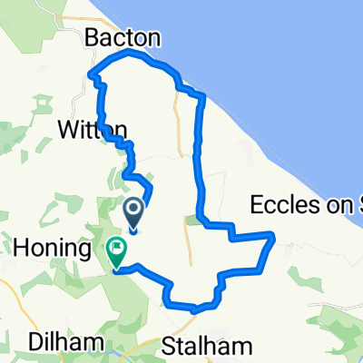
Overview
About this route
Happisburgh run
- -:--
- Duration
- 29.4 km
- Distance
- 21 m
- Ascent
- 21 m
- Descent
- ---
- Avg. speed
- ---
- Max. altitude

Route quality
Waytypes & surfaces along the route
Waytypes
Road
25 km
(85 %)
Quiet road
3.5 km
(12 %)
Surfaces
Paved
12.1 km
(41 %)
Unpaved
0.6 km
(2 %)
Asphalt
12.1 km
(41 %)
Pebblestone
0.6 km
(2 %)
Undefined
16.8 km
(57 %)
Route highlights
Points of interest along the route
Point of interest after 0 km
Point of interest after 10.7 km

Point of interest after 15 km
Continue with Bikemap
Use, edit, or download this cycling route
You would like to ride Recording from 2 Nov 2016, 13:03 or customize it for your own trip? Here is what you can do with this Bikemap route:
Free features
- Save this route as favorite or in collections
- Copy & plan your own version of this route
- Sync your route with Garmin or Wahoo
Premium features
Free trial for 3 days, or one-time payment. More about Bikemap Premium.
- Navigate this route on iOS & Android
- Export a GPX / KML file of this route
- Create your custom printout (try it for free)
- Download this route for offline navigation
Discover more Premium features.
Get Bikemap PremiumFrom our community
Other popular routes starting in East Ruston
 kidsride
- Distance
- 23.4 km
- Ascent
- 30 m
- Descent
- 33 m
- Location
- East Ruston, England, United Kingdom
 2gtmass
- Distance
- 59.9 km
- Ascent
- 204 m
- Descent
- 141 m
- Location
- East Ruston, England, United Kingdom
 test2hautbois
- Distance
- 9.3 km
- Ascent
- 9 m
- Descent
- 19 m
- Location
- East Ruston, England, United Kingdom
 xcountry1
- Distance
- 100.3 km
- Ascent
- 280 m
- Descent
- 205 m
- Location
- East Ruston, England, United Kingdom
 Norfolk 20k spin
- Distance
- 20.7 km
- Ascent
- 24 m
- Descent
- 24 m
- Location
- East Ruston, England, United Kingdom
 worstead2blakeney
- Distance
- 42.9 km
- Ascent
- 176 m
- Descent
- 169 m
- Location
- East Ruston, England, United Kingdom
 33k flat spin
- Distance
- 33 km
- Ascent
- 25 m
- Descent
- 27 m
- Location
- East Ruston, England, United Kingdom
 Walcott to coltishall (frog bridge)
- Distance
- 19.1 km
- Ascent
- 38 m
- Descent
- 35 m
- Location
- East Ruston, England, United Kingdom
Open it in the app