

Haiger & Umgebung
Steinbach - Kalteiche - Holzhausen - Allendorf - Steinbach
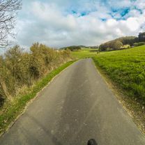
A cycling route starting in Haiger, Hesse, Germany.
Overview
About this route
Training route from Haiger-Steinbach, via Kalteiche, towards Burbach, then towards Holzhausen, then via Allendorf back to Steinbach.
Route description => It goes over paved roads, forest paths (in good condition => gravel, stones, dirt). From Kalteiche it continues along district roads towards Burbach and Holzhausen. Beware on the descent to Holzhausen as you gain a lot of speed. Check your brakes before the ride. Just before Holzhausen, the route follows bike paths and gravel roads back to Steinbach.
On my first ride, I took slightly less than 1 hour and 10 minutes.
- -:--
- Duration
- 18.6 km
- Distance
- 294 m
- Ascent
- 294 m
- Descent
- ---
- Avg. speed
- ---
- Max. altitude

Part of
11 stages
Route quality
Waytypes & surfaces along the route
Waytypes
Track
7.8 km
(42 %)
Quiet road
3.3 km
(18 %)
Surfaces
Paved
10.8 km
(58 %)
Unpaved
5.8 km
(31 %)
Asphalt
10 km
(54 %)
Gravel
4.8 km
(26 %)
Continue with Bikemap
Use, edit, or download this cycling route
You would like to ride Steinbach - Kalteiche - Holzhausen - Allendorf - Steinbach or customize it for your own trip? Here is what you can do with this Bikemap route:
Free features
- Save this route as favorite or in collections
- Copy & plan your own version of this route
- Sync your route with Garmin or Wahoo
Premium features
Free trial for 3 days, or one-time payment. More about Bikemap Premium.
- Navigate this route on iOS & Android
- Export a GPX / KML file of this route
- Create your custom printout (try it for free)
- Download this route for offline navigation
Discover more Premium features.
Get Bikemap PremiumFrom our community
Other popular routes starting in Haiger
 Dill Lahn Tag1.
- Distance
- 66.4 km
- Ascent
- 160 m
- Descent
- 306 m
- Location
- Haiger, Hesse, Germany
 2013 Runde Roßbachtal Mit Auerhahnhütte
- Distance
- 20.5 km
- Ascent
- 381 m
- Descent
- 381 m
- Location
- Haiger, Hesse, Germany
 RR_57km_991hm_Steinbach_HM-Training
- Distance
- 63.4 km
- Ascent
- 908 m
- Descent
- 907 m
- Location
- Haiger, Hesse, Germany
 Langenaubach Burbach Rundtour
- Distance
- 48.9 km
- Ascent
- 966 m
- Descent
- 966 m
- Location
- Haiger, Hesse, Germany
 Fuchkaute und zurück
- Distance
- 41.4 km
- Ascent
- 549 m
- Descent
- 549 m
- Location
- Haiger, Hesse, Germany
 Ostersonntag Gassi-Radtour
- Distance
- 25.4 km
- Ascent
- 486 m
- Descent
- 486 m
- Location
- Haiger, Hesse, Germany
 Haiger Dillenburg Donsbach
- Distance
- 17.5 km
- Ascent
- 688 m
- Descent
- 775 m
- Location
- Haiger, Hesse, Germany
 Entspannende Route in Haiger
- Distance
- 11.3 km
- Ascent
- 179 m
- Descent
- 152 m
- Location
- Haiger, Hesse, Germany
Open it in the app