

2 Pt Lichtenstein to Semonzo to Rifugio Bassano
A cycling route starting in Unterhausen, Baden-Wurttemberg, Germany.
Overview
About this route
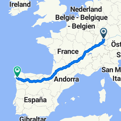
Start (Control): Semonzo, TBC
Closes: Wednesday 2nd August
Approx min distance from start: 1150km
Finish: Rifugio Bassano, Cima Grappa
Co-ordinates: 45.873373, 11.803304
- -:--
- Duration
- 585.8 km
- Distance
- 4,422 m
- Ascent
- 3,518 m
- Descent
- ---
- Avg. speed
- ---
- Max. altitude

Route quality
Waytypes & surfaces along the route
Waytypes
Quiet road
111.3 km
(19 %)
Track
105.4 km
(18 %)
Surfaces
Paved
486.2 km
(83 %)
Unpaved
58.6 km
(10 %)
Asphalt
480.4 km
(82 %)
Gravel
35.1 km
(6 %)
Continue with Bikemap
Use, edit, or download this cycling route
You would like to ride 2 Pt Lichtenstein to Semonzo to Rifugio Bassano or customize it for your own trip? Here is what you can do with this Bikemap route:
Free features
- Save this route as favorite or in collections
- Copy & plan your own version of this route
- Split it into stages to create a multi-day tour
- Sync your route with Garmin or Wahoo
Premium features
Free trial for 3 days, or one-time payment. More about Bikemap Premium.
- Navigate this route on iOS & Android
- Export a GPX / KML file of this route
- Create your custom printout (try it for free)
- Download this route for offline navigation
Discover more Premium features.
Get Bikemap PremiumFrom our community
Other popular routes starting in Unterhausen
 germany-swizz-france-spain
- Distance
- 2,110.7 km
- Ascent
- 6,122 m
- Descent
- 6,041 m
- Location
- Unterhausen, Baden-Wurttemberg, Germany
 Sonnenbühl-Trochtelfingen-Engstingen-Sonnenbühl
- Distance
- 44.3 km
- Ascent
- 366 m
- Descent
- 411 m
- Location
- Unterhausen, Baden-Wurttemberg, Germany
 Große Erbse
- Distance
- 78.3 km
- Ascent
- 766 m
- Descent
- 699 m
- Location
- Unterhausen, Baden-Wurttemberg, Germany
 Schöne Albtour
- Distance
- 46.4 km
- Ascent
- 563 m
- Descent
- 602 m
- Location
- Unterhausen, Baden-Wurttemberg, Germany
 Genkingen-Gomadingen-Hohenstein-Genkingen
- Distance
- 58.3 km
- Ascent
- 522 m
- Descent
- 542 m
- Location
- Unterhausen, Baden-Wurttemberg, Germany
 2 Pt Lichtenstein to Semonzo to Rifugio Bassano
- Distance
- 585.8 km
- Ascent
- 4,422 m
- Descent
- 3,518 m
- Location
- Unterhausen, Baden-Wurttemberg, Germany
 germany-swizz-france-spain
- Distance
- 2,113.2 km
- Ascent
- 5,034 m
- Descent
- 5,346 m
- Location
- Unterhausen, Baden-Wurttemberg, Germany
 Große Burladinger Runde
- Distance
- 97.8 km
- Ascent
- 1,132 m
- Descent
- 1,156 m
- Location
- Unterhausen, Baden-Wurttemberg, Germany
Open it in the app