

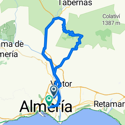
ALMERIA-AGUADULCE ENDURO
A cycling route starting in Huércal de Almería, Andalusia, Spain.
Overview
About this route
Route to do with an enduro bike. High technical level. Medium-high physical level.
- -:--
- Duration
- 25.1 km
- Distance
- 841 m
- Ascent
- 834 m
- Descent
- ---
- Avg. speed
- ---
- Max. altitude

Route highlights
Points of interest along the route
Point of interest after 21.6 km
ALJIBE
Continue with Bikemap
Use, edit, or download this cycling route
You would like to ride ALMERIA-AGUADULCE ENDURO or customize it for your own trip? Here is what you can do with this Bikemap route:
Free features
- Save this route as favorite or in collections
- Copy & plan your own version of this route
- Sync your route with Garmin or Wahoo
Premium features
Free trial for 3 days, or one-time payment. More about Bikemap Premium.
- Navigate this route on iOS & Android
- Export a GPX / KML file of this route
- Create your custom printout (try it for free)
- Download this route for offline navigation
Discover more Premium features.
Get Bikemap PremiumFrom our community
Other popular routes starting in Huércal de Almería
 Chilindro
- Distance
- 14.9 km
- Ascent
- 825 m
- Descent
- 547 m
- Location
- Huércal de Almería, Andalusia, Spain
 Piedras Redondas-Quemadero-El Potro
- Distance
- 31.4 km
- Ascent
- 665 m
- Descent
- 660 m
- Location
- Huércal de Almería, Andalusia, Spain
 Huercal - Cerro de la Cruz
- Distance
- 67.3 km
- Ascent
- 1,043 m
- Descent
- 1,043 m
- Location
- Huércal de Almería, Andalusia, Spain
 AGAVE-Cerro de la Sima-Cerro de la Víbora-Cerro Gallado-El Pocico-Sendero Tizón-Sendero de María-AGAVE
- Distance
- 11.9 km
- Ascent
- 607 m
- Descent
- 739 m
- Location
- Huércal de Almería, Andalusia, Spain
 BAÑOS DE SIERRA ALHAMILLA_BENAHADUX
- Distance
- 42.3 km
- Ascent
- 640 m
- Descent
- 674 m
- Location
- Huércal de Almería, Andalusia, Spain
 Fuente de Las Maravillas
- Distance
- 31.3 km
- Ascent
- 493 m
- Descent
- 39 m
- Location
- Huércal de Almería, Andalusia, Spain
 Camino del Potro, Sendero a Alhama y Toboganes
- Distance
- 22.1 km
- Ascent
- 671 m
- Descent
- 620 m
- Location
- Huércal de Almería, Andalusia, Spain
 Almeria - Antenas Sierra Alhamilla - Los Baños
- Distance
- 61.7 km
- Ascent
- 1,221 m
- Descent
- 1,296 m
- Location
- Huércal de Almería, Andalusia, Spain
Open it in the app