

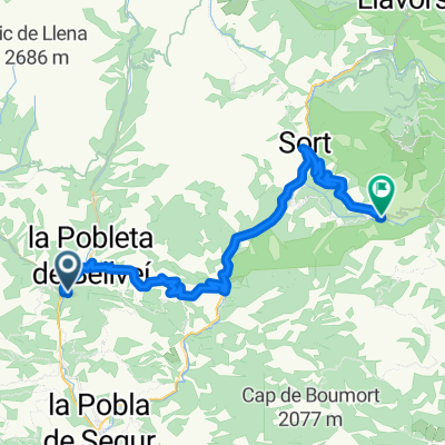
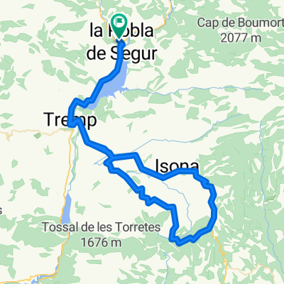
Brevet Randonneur 200K2 Pobla de Segur 2017
A cycling route starting in Senterada, Catalonia, Spain.
Overview
About this route
Brevet Randonneur 200K2 Pobla de Segur 2017
- -:--
- Duration
- 205.9 km
- Distance
- 1,558 m
- Ascent
- 1,561 m
- Descent
- ---
- Avg. speed
- ---
- Max. altitude

Route quality
Waytypes & surfaces along the route
Waytypes
Track
18.5 km
(9 %)
Road
14.4 km
(7 %)
Surfaces
Paved
86.5 km
(42 %)
Unpaved
10.3 km
(5 %)
Asphalt
82.4 km
(40 %)
Paved (undefined)
4.1 km
(2 %)
Continue with Bikemap
Use, edit, or download this cycling route
You would like to ride Brevet Randonneur 200K2 Pobla de Segur 2017 or customize it for your own trip? Here is what you can do with this Bikemap route:
Free features
- Save this route as favorite or in collections
- Copy & plan your own version of this route
- Split it into stages to create a multi-day tour
- Sync your route with Garmin or Wahoo
Premium features
Free trial for 3 days, or one-time payment. More about Bikemap Premium.
- Navigate this route on iOS & Android
- Export a GPX / KML file of this route
- Create your custom printout (try it for free)
- Download this route for offline navigation
Discover more Premium features.
Get Bikemap PremiumFrom our community
Other popular routes starting in Senterada
 Senterada - Sort
- Distance
- 45.9 km
- Ascent
- 1,684 m
- Descent
- 1,149 m
- Location
- Senterada, Catalonia, Spain
 Pobla-Viella (Por el Túnel)
- Distance
- 79.5 km
- Ascent
- 2,521 m
- Descent
- 2,052 m
- Location
- Senterada, Catalonia, Spain
 Ribes de Freser - Boí Taull
- Distance
- 237.6 km
- Ascent
- 2,707 m
- Descent
- 4,007 m
- Location
- Senterada, Catalonia, Spain
 Brevet Randonneur 200K2 Pobla de Segur 2017
- Distance
- 205.9 km
- Ascent
- 1,558 m
- Descent
- 1,561 m
- Location
- Senterada, Catalonia, Spain
 Sort 3
- Distance
- 113.8 km
- Ascent
- 2,788 m
- Descent
- 2,791 m
- Location
- Senterada, Catalonia, Spain
 Baix Pallars to La Seu d'Urgell
- Distance
- 93.2 km
- Ascent
- 4,078 m
- Descent
- 3,946 m
- Location
- Senterada, Catalonia, Spain
 Vuelta Alt de Comiols por San Salvador Toló
- Distance
- 87.4 km
- Ascent
- 942 m
- Descent
- 942 m
- Location
- Senterada, Catalonia, Spain
 Pirineos-07: Pobla del Segur - Cabdella
- Distance
- 53.9 km
- Ascent
- 1,200 m
- Descent
- 1,325 m
- Location
- Senterada, Catalonia, Spain
Open it in the app