

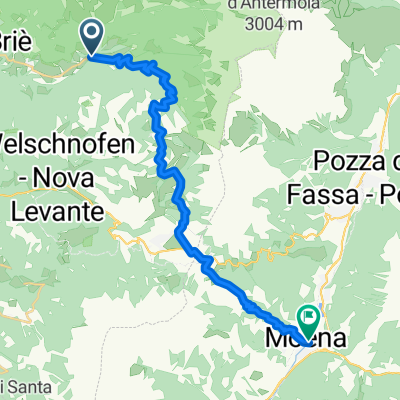
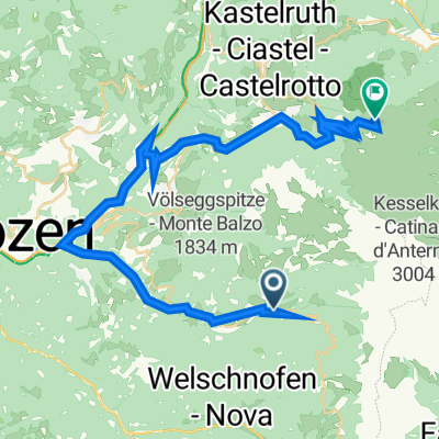
St. Zyprian Moena
A cycling route starting in Tiers, Trentino-Alto Adige, Italy.
Overview
About this route
St. Zyprian - Niger Pass - Karer Pass - Moena
- -:--
- Duration
- 22.4 km
- Distance
- 740 m
- Ascent
- 648 m
- Descent
- ---
- Avg. speed
- ---
- Max. altitude
Route quality
Waytypes & surfaces along the route
Waytypes
Track
4.7 km
(21 %)
Path
1.3 km
(6 %)
Surfaces
Paved
11 km
(49 %)
Unpaved
3.1 km
(14 %)
Asphalt
11 km
(49 %)
Gravel
3.1 km
(14 %)
Undefined
8.3 km
(37 %)
Continue with Bikemap
Use, edit, or download this cycling route
You would like to ride St. Zyprian Moena or customize it for your own trip? Here is what you can do with this Bikemap route:
Free features
- Save this route as favorite or in collections
- Copy & plan your own version of this route
- Sync your route with Garmin or Wahoo
Premium features
Free trial for 3 days, or one-time payment. More about Bikemap Premium.
- Navigate this route on iOS & Android
- Export a GPX / KML file of this route
- Create your custom printout (try it for free)
- Download this route for offline navigation
Discover more Premium features.
Get Bikemap PremiumFrom our community
Other popular routes starting in Tiers
 Tierser Runde
- Distance
- 11.4 km
- Ascent
- 738 m
- Descent
- 123 m
- Location
- Tiers, Trentino-Alto Adige, Italy
 Nigerpass / Rosengarten-Latemar
- Distance
- 32.7 km
- Ascent
- 1,110 m
- Descent
- 1,110 m
- Location
- Tiers, Trentino-Alto Adige, Italy
 St. Zyprian Moena
- Distance
- 22.4 km
- Ascent
- 740 m
- Descent
- 648 m
- Location
- Tiers, Trentino-Alto Adige, Italy
 StZyprian-Moena
- Distance
- 22.5 km
- Ascent
- 721 m
- Descent
- 615 m
- Location
- Tiers, Trentino-Alto Adige, Italy
 07 - Nova Levante_Welschnofen-Obergummer_Gummer(San Valentino) - Nova Levante/Welschnofen-Obergummer/Gummer(San Valentino)
- Distance
- 49.6 km
- Ascent
- 2,049 m
- Descent
- 2,046 m
- Location
- Tiers, Trentino-Alto Adige, Italy
 Dynamite Trail - Tag 6 (Tiers - Refugio Refavaie)
- Distance
- 57.7 km
- Ascent
- 1,897 m
- Descent
- 1,791 m
- Location
- Tiers, Trentino-Alto Adige, Italy
 St-Zyprian-Straße 69, Tiers nach Via Compatsch 62, Kastelruth
- Distance
- 36.9 km
- Ascent
- 2,198 m
- Descent
- 1,480 m
- Location
- Tiers, Trentino-Alto Adige, Italy
 Nova Levante_Welschnofen-Obergummer_Gummer (San Valentino)
- Distance
- 42 km
- Ascent
- 1,674 m
- Descent
- 1,674 m
- Location
- Tiers, Trentino-Alto Adige, Italy
Open it in the app