

Curves
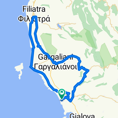
A cycling route starting in Gargaliánoi, Peloponnese, Greece.
Overview
About this route
A unique tour that take us deep into the Messinian mountains going through olive groves and vineyards. We start climbing up to Nestor’s Palace and continue up to Platanobrysi at 704m. Then we roll down to Messini and turn right to the mountains once more towards Vlachopoulo going past lots of tiny traditional villages. On our way down we enjoy the view of the Ionian Sea and back to Costa Navarino.
- -:--
- Duration
- 101.9 km
- Distance
- 1,338 m
- Ascent
- 1,338 m
- Descent
- ---
- Avg. speed
- ---
- Max. altitude

Route quality
Waytypes & surfaces along the route
Waytypes
Busy road
43.1 km
(42 %)
Road
30.5 km
(30 %)
Surfaces
Paved
62.8 km
(62 %)
Asphalt
57.9 km
(57 %)
Paved (undefined)
3.7 km
(4 %)
Continue with Bikemap
Use, edit, or download this cycling route
You would like to ride Curves or customize it for your own trip? Here is what you can do with this Bikemap route:
Free features
- Save this route as favorite or in collections
- Copy & plan your own version of this route
- Split it into stages to create a multi-day tour
- Sync your route with Garmin or Wahoo
Premium features
Free trial for 3 days, or one-time payment. More about Bikemap Premium.
- Navigate this route on iOS & Android
- Export a GPX / KML file of this route
- Create your custom printout (try it for free)
- Download this route for offline navigation
Discover more Premium features.
Get Bikemap PremiumFrom our community
Other popular routes starting in Gargaliánoi
 Marathopoli-Gargalianoi
- Distance
- 33.9 km
- Ascent
- 395 m
- Descent
- 395 m
- Location
- Gargaliánoi, Peloponnese, Greece
 BTR Ionian Views
- Distance
- 8.2 km
- Ascent
- 14 m
- Descent
- 270 m
- Location
- Gargaliánoi, Peloponnese, Greece
 e-bike tour Eleofyto
- Distance
- 20.6 km
- Ascent
- 330 m
- Descent
- 330 m
- Location
- Gargaliánoi, Peloponnese, Greece
 Costa Navarino - Chora - Gargalianoi - Filiatra
- Distance
- 62.5 km
- Ascent
- 579 m
- Descent
- 579 m
- Location
- Gargaliánoi, Peloponnese, Greece
 Navarino Outdoors - Bike Fitness
- Distance
- 14.2 km
- Ascent
- 248 m
- Descent
- 248 m
- Location
- Gargaliánoi, Peloponnese, Greece
 Costa Navarino - Chora - Rizomylos - Koroni
- Distance
- 70.1 km
- Ascent
- 721 m
- Descent
- 726 m
- Location
- Gargaliánoi, Peloponnese, Greece
 Buena Vista
- Distance
- 34.2 km
- Ascent
- 578 m
- Descent
- 577 m
- Location
- Gargaliánoi, Peloponnese, Greece
 CN-Pyla-Balodimaiika-Gialova
- Distance
- 31.5 km
- Ascent
- 252 m
- Descent
- 252 m
- Location
- Gargaliánoi, Peloponnese, Greece
Open it in the app