

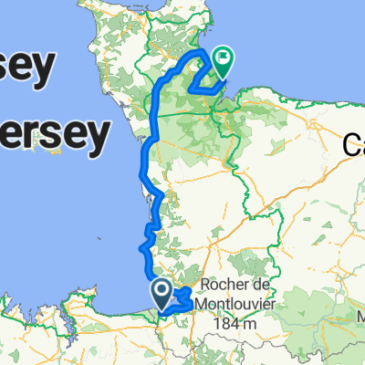
Mont Saint Michel via St Malo to Vannes
A cycling route starting in Pontorson, Normandy, France.
Overview
About this route
V1 of Mt St Michel to Vannes and to Beack campground
- -:--
- Duration
- 223.3 km
- Distance
- 563 m
- Ascent
- 546 m
- Descent
- ---
- Avg. speed
- ---
- Max. altitude
Route quality
Waytypes & surfaces along the route
Waytypes
Busy road
94.4 km
(42 %)
Quiet road
59.2 km
(26 %)
Surfaces
Paved
103.1 km
(46 %)
Unpaved
1.9 km
(<1 %)
Asphalt
100.2 km
(45 %)
Concrete
2.4 km
(1 %)
Continue with Bikemap
Use, edit, or download this cycling route
You would like to ride Mont Saint Michel via St Malo to Vannes or customize it for your own trip? Here is what you can do with this Bikemap route:
Free features
- Save this route as favorite or in collections
- Copy & plan your own version of this route
- Split it into stages to create a multi-day tour
- Sync your route with Garmin or Wahoo
Premium features
Free trial for 3 days, or one-time payment. More about Bikemap Premium.
- Navigate this route on iOS & Android
- Export a GPX / KML file of this route
- Create your custom printout (try it for free)
- Download this route for offline navigation
Discover more Premium features.
Get Bikemap PremiumFrom our community
Other popular routes starting in Pontorson
 voyage bretagne
- Distance
- 42.2 km
- Ascent
- 56 m
- Descent
- 14 m
- Location
- Pontorson, Normandy, France
 Pontorson to Vitre
- Distance
- 66.7 km
- Ascent
- 359 m
- Descent
- 309 m
- Location
- Pontorson, Normandy, France
 16/05 Bretagnetour
- Distance
- 46.6 km
- Ascent
- 58 m
- Descent
- 48 m
- Location
- Pontorson, Normandy, France
 26/05* PONTORSON-RENNES 65.2 KM , CICLOVIA BEIRANDO O CANAL À DIREITA COM MENOS TRAFICO
- Distance
- 65.2 km
- Ascent
- 234 m
- Descent
- 210 m
- Location
- Pontorson, Normandy, France
 TOUR DE BRETAGNE
- Distance
- 821.4 km
- Ascent
- 1,079 m
- Descent
- 1,081 m
- Location
- Pontorson, Normandy, France
 3 Place de la Gare, Pontorson to 37 Rue du Port, Cancale
- Distance
- 53.5 km
- Ascent
- 106 m
- Descent
- 82 m
- Location
- Pontorson, Normandy, France
 Tour de France 2016 - Stage 1
- Distance
- 190.7 km
- Ascent
- 443 m
- Descent
- 445 m
- Location
- Pontorson, Normandy, France
 Route to Le Grand Enclos Ardevon, 50170 Pontorson
- Distance
- 7.5 km
- Ascent
- 0 m
- Descent
- 0 m
- Location
- Pontorson, Normandy, France
Open it in the app