

Belisario Quevedo.cara.este.putzalahua
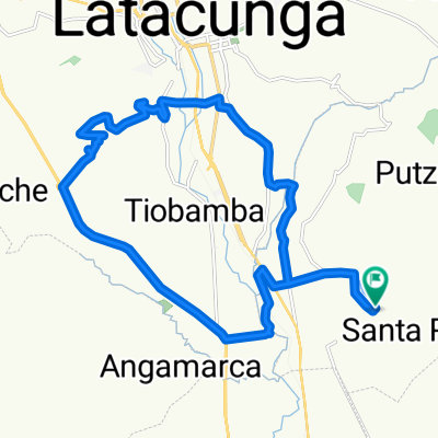
A cycling route starting in San Miguel de Salcedo, Cotopaxi, Ecuador.
Overview
About this route
freedom
- 2 h 15 min
- Duration
- 25.7 km
- Distance
- 689 m
- Ascent
- 686 m
- Descent
- 11.4 km/h
- Avg. speed
- ---
- Max. altitude

Route photos

Route quality
Waytypes & surfaces along the route
Waytypes
Quiet road
10.3 km
(40 %)
Track
7.7 km
(30 %)
Surfaces
Paved
4.4 km
(17 %)
Unpaved
0.3 km
(1 %)
Asphalt
4.4 km
(17 %)
Unpaved (undefined)
0.3 km
(1 %)
Undefined
21.1 km
(82 %)
Continue with Bikemap
Use, edit, or download this cycling route
You would like to ride Belisario Quevedo.cara.este.putzalahua or customize it for your own trip? Here is what you can do with this Bikemap route:
Free features
- Save this route as favorite or in collections
- Copy & plan your own version of this route
- Sync your route with Garmin or Wahoo
Premium features
Free trial for 3 days, or one-time payment. More about Bikemap Premium.
- Navigate this route on iOS & Android
- Export a GPX / KML file of this route
- Create your custom printout (try it for free)
- Download this route for offline navigation
Discover more Premium features.
Get Bikemap PremiumFrom our community
Other popular routes starting in San Miguel de Salcedo
 sin límites house.latacunga.culahuango.house
- Distance
- 14.4 km
- Ascent
- 454 m
- Descent
- 455 m
- Location
- San Miguel de Salcedo, Cotopaxi, Ecuador
 Belisario Quevedo _ PUTZALAHUA
- Distance
- 26.5 km
- Ascent
- ---
- Descent
- ---
- Location
- San Miguel de Salcedo, Cotopaxi, Ecuador
 Belisario Quevedo.cara.este.putzalahua
- Distance
- 25.7 km
- Ascent
- 689 m
- Descent
- 686 m
- Location
- San Miguel de Salcedo, Cotopaxi, Ecuador
 Belisario Quevedo. laguna Yambo
- Distance
- 34.1 km
- Ascent
- 406 m
- Descent
- 408 m
- Location
- San Miguel de Salcedo, Cotopaxi, Ecuador
 ride through Belisario Quevedo
- Distance
- 27.3 km
- Ascent
- 477 m
- Descent
- 474 m
- Location
- San Miguel de Salcedo, Cotopaxi, Ecuador
 Belisario Quevedo _ Latacunga
- Distance
- 33.1 km
- Ascent
- 266 m
- Descent
- 284 m
- Location
- San Miguel de Salcedo, Cotopaxi, Ecuador
 RUTA PANZALEO-BAÑOS EMBICIADOS DEL ZURICH
- Distance
- 62.9 km
- Ascent
- 605 m
- Descent
- 1,405 m
- Location
- San Miguel de Salcedo, Cotopaxi, Ecuador
 De Julio Hidalgo, Salcedo a Julio Hidalgo, Salcedo
- Distance
- 49.1 km
- Ascent
- 1,439 m
- Descent
- 1,440 m
- Location
- San Miguel de Salcedo, Cotopaxi, Ecuador
Open it in the app