

Bike GPS RichTrack Factory Track
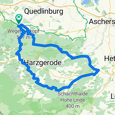
A cycling route starting in Thale, Saxony-Anhalt, Germany.
Overview
About this route
TEASI track
- -:--
- Duration
- 48.9 km
- Distance
- 390 m
- Ascent
- 386 m
- Descent
- ---
- Avg. speed
- ---
- Max. altitude
Route quality
Waytypes & surfaces along the route
Waytypes
Track
19.5 km
(40 %)
Path
19.5 km
(40 %)
Surfaces
Paved
7.8 km
(16 %)
Unpaved
36.2 km
(74 %)
Ground
14.2 km
(29 %)
Sand
9.8 km
(20 %)
Route highlights
Points of interest along the route
Point of interest after 0 km
001
Point of interest after 1 km
002
Point of interest after 1.6 km
003
Point of interest after 4.7 km
004
Point of interest after 5.1 km
005
Point of interest after 5.7 km
006
Point of interest after 9 km
007
Point of interest after 9.4 km
008
Point of interest after 10.1 km
009
Point of interest after 10.7 km
010
Continue with Bikemap
Use, edit, or download this cycling route
You would like to ride Bike GPS RichTrack Factory Track or customize it for your own trip? Here is what you can do with this Bikemap route:
Free features
- Save this route as favorite or in collections
- Copy & plan your own version of this route
- Sync your route with Garmin or Wahoo
Premium features
Free trial for 3 days, or one-time payment. More about Bikemap Premium.
- Navigate this route on iOS & Android
- Export a GPX / KML file of this route
- Create your custom printout (try it for free)
- Download this route for offline navigation
Discover more Premium features.
Get Bikemap PremiumFrom our community
Other popular routes starting in Thale
 Thale Klostercamping - stolelift til Rostreppe
- Distance
- 3.3 km
- Ascent
- 33 m
- Descent
- 4 m
- Location
- Thale, Saxony-Anhalt, Germany
 vom Harz zum Rennsteig -Entwurf
- Distance
- 195.2 km
- Ascent
- 1,850 m
- Descent
- 1,829 m
- Location
- Thale, Saxony-Anhalt, Germany
 Karl-Marx-Straße, Thale nach Karl-Marx-Straße, Thale
- Distance
- 30.3 km
- Ascent
- 256 m
- Descent
- 253 m
- Location
- Thale, Saxony-Anhalt, Germany
 Harz 2010 01
- Distance
- 83.5 km
- Ascent
- 964 m
- Descent
- 964 m
- Location
- Thale, Saxony-Anhalt, Germany
 Thale _ Braunlage
- Distance
- 105.4 km
- Ascent
- 1,187 m
- Descent
- 1,187 m
- Location
- Thale, Saxony-Anhalt, Germany
 Connis Route
- Distance
- 38.7 km
- Ascent
- 812 m
- Descent
- 812 m
- Location
- Thale, Saxony-Anhalt, Germany
 Thale: Rübchen und Steinköpfe
- Distance
- 14 km
- Ascent
- 296 m
- Descent
- 296 m
- Location
- Thale, Saxony-Anhalt, Germany
 97 1610 Thale Biesen Wippra FBR
- Distance
- 96.7 km
- Ascent
- 1,148 m
- Descent
- 1,145 m
- Location
- Thale, Saxony-Anhalt, Germany
Open it in the app