
2016_do_CP1
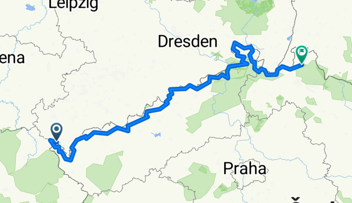
A cycling route starting in Bad Elster, Saxony, Germany.
Overview
About this route
Trasa závodu ISOMA 1000 miles Adventure 2016 od startu do CheckPointu 1
- -:--
- Duration
- 464.2 km
- Distance
- 2,749 m
- Ascent
- 2,939 m
- Descent
- ---
- Avg. speed
- ---
- Max. altitude

Route highlights
Points of interest along the route
Point of interest after 462.6 km
Zákaz noční jízdy v době od 20 do 6 hodin
Point of interest after 462.6 km
5 Konec zákazu
Point of interest after 462.6 km
Zákaz noční jízdy v době od 20 do 6 hodin
Point of interest after 462.6 km
4 Konec zákazu
Point of interest after 462.6 km
Zákaz noční jízdy v době od 20 do 6 hodin
Point of interest after 462.6 km
3 Konec zákazu
Point of interest after 462.6 km
Zákaz noční jízdy v době od 20 do 6 hodin
Point of interest after 462.6 km
2 Konec zákazu
Point of interest after 462.6 km
Zákaz noční jízdy v době od 20 do 6 hodin
Point of interest after 462.6 km
1 Konec zákazu
Continue with Bikemap
Use, edit, or download this cycling route
You would like to ride 2016_do_CP1 or customize it for your own trip? Here is what you can do with this Bikemap route:
Free features
- Save this route as favorite or in collections
- Copy & plan your own version of this route
- Split it into stages to create a multi-day tour
- Sync your route with Garmin or Wahoo
Premium features
Free trial for 3 days, or one-time payment. More about Bikemap Premium.
- Navigate this route on iOS & Android
- Export a GPX / KML file of this route
- Create your custom printout (try it for free)
- Download this route for offline navigation
Discover more Premium features.
Get Bikemap PremiumFrom our community
Other popular routes starting in Bad Elster
 Alter Bahnhof
- Distance
- 12 km
- Ascent
- 323 m
- Descent
- 318 m
- Location
- Bad Elster, Saxony, Germany
 Heimweg Elsterradweg
- Distance
- 3.3 km
- Ascent
- 63 m
- Descent
- 59 m
- Location
- Bad Elster, Saxony, Germany
 GT2-9 Bad Elster-Klingenthal
- Distance
- 55.3 km
- Ascent
- 925 m
- Descent
- 818 m
- Location
- Bad Elster, Saxony, Germany
 Bad Elster - Tschechei - Bad Elster CLONED FROM ROUTE 876186
- Distance
- 25.2 km
- Ascent
- 313 m
- Descent
- 313 m
- Location
- Bad Elster, Saxony, Germany
 2023_07 Studánka - Trojmezí pěšky
- Distance
- 9.4 km
- Ascent
- 95 m
- Descent
- 157 m
- Location
- Bad Elster, Saxony, Germany
 Bad Elster - Sohl - Remtengrün - Mühlhausen - Bad Elster
- Distance
- 19 km
- Ascent
- 423 m
- Descent
- 422 m
- Location
- Bad Elster, Saxony, Germany
 BE - Vernérov - BE
- Distance
- 24.7 km
- Ascent
- 300 m
- Descent
- 300 m
- Location
- Bad Elster, Saxony, Germany
 Trailtour an der Grenze
- Distance
- 34.7 km
- Ascent
- 547 m
- Descent
- 549 m
- Location
- Bad Elster, Saxony, Germany
Open it in the app