

Lake Hamana 1
A cycling route starting in Kosai-shi, Shizuoka, Japan.
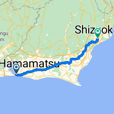
Overview
About this route
舘山寺 - 弁天島
- -:--
- Duration
- 38.7 km
- Distance
- 23 m
- Ascent
- 23 m
- Descent
- ---
- Avg. speed
- ---
- Max. altitude

Route quality
Waytypes & surfaces along the route
Waytypes
Pedestrian area
12.4 km
(32 %)
Road
5 km
(13 %)
Surfaces
Paved
31.4 km
(81 %)
Asphalt
29.4 km
(76 %)
Paved (undefined)
1.9 km
(5 %)
Undefined
7.4 km
(19 %)
Continue with Bikemap
Use, edit, or download this cycling route
You would like to ride Lake Hamana 1 or customize it for your own trip? Here is what you can do with this Bikemap route:
Free features
- Save this route as favorite or in collections
- Copy & plan your own version of this route
- Sync your route with Garmin or Wahoo
Premium features
Free trial for 3 days, or one-time payment. More about Bikemap Premium.
- Navigate this route on iOS & Android
- Export a GPX / KML file of this route
- Create your custom printout (try it for free)
- Download this route for offline navigation
Discover more Premium features.
Get Bikemap PremiumFrom our community
Other popular routes starting in Kosai-shi
 Lake Hamana 2
- Distance
- 27.2 km
- Ascent
- 164 m
- Descent
- 164 m
- Location
- Kosai-shi, Shizuoka, Japan
 Hamanako Enjoy Route
- Distance
- 74.5 km
- Ascent
- 201 m
- Descent
- 200 m
- Location
- Kosai-shi, Shizuoka, Japan
 07 Kosai to Irago
- Distance
- 59 km
- Ascent
- 351 m
- Descent
- 350 m
- Location
- Kosai-shi, Shizuoka, Japan
 2017/2/8
- Distance
- 93.3 km
- Ascent
- 212 m
- Descent
- 212 m
- Location
- Kosai-shi, Shizuoka, Japan
 Day 6 Lake Hamana - Toyohashi 🌧️🌧️🌧️
- Distance
- 19.7 km
- Ascent
- 86 m
- Descent
- 67 m
- Location
- Kosai-shi, Shizuoka, Japan
 Japan 2013, Day17, Lake Inohana - Yui
- Distance
- 147.9 km
- Ascent
- 540 m
- Descent
- 520 m
- Location
- Kosai-shi, Shizuoka, Japan
 Бентендзима Шидзуока
- Distance
- 98.7 km
- Ascent
- 993 m
- Descent
- 965 m
- Location
- Kosai-shi, Shizuoka, Japan
 Murakushicho, Nishi-Ku, Hamamatsu-Shi to Murakushicho, Nishi-Ku, Hamamatsu-Shi
- Distance
- 68.8 km
- Ascent
- 0 m
- Descent
- 6 m
- Location
- Kosai-shi, Shizuoka, Japan
Open it in the app