

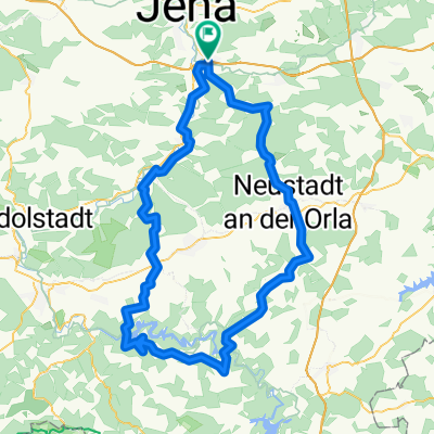
Jena/Göschwitz - Weißenfels
A cycling route starting in Sulza, Thuringia, Germany.
Overview
About this route
4.Etappe
- -:--
- Duration
- 70.9 km
- Distance
- 268 m
- Ascent
- 330 m
- Descent
- ---
- Avg. speed
- ---
- Max. altitude
Route quality
Waytypes & surfaces along the route
Waytypes
Quiet road
20.2 km
(29 %)
Track
12.2 km
(17 %)
Surfaces
Paved
63.7 km
(90 %)
Unpaved
2.4 km
(3 %)
Asphalt
58.6 km
(83 %)
Paving stones
3.4 km
(5 %)
Continue with Bikemap
Use, edit, or download this cycling route
You would like to ride Jena/Göschwitz - Weißenfels or customize it for your own trip? Here is what you can do with this Bikemap route:
Free features
- Save this route as favorite or in collections
- Copy & plan your own version of this route
- Sync your route with Garmin or Wahoo
Premium features
Free trial for 3 days, or one-time payment. More about Bikemap Premium.
- Navigate this route on iOS & Android
- Export a GPX / KML file of this route
- Create your custom printout (try it for free)
- Download this route for offline navigation
Discover more Premium features.
Get Bikemap PremiumFrom our community
Other popular routes starting in Sulza
 Chillige Abendtour durch die westlichen Berge Jenas
- Distance
- 49.9 km
- Ascent
- 469 m
- Descent
- 459 m
- Location
- Sulza, Thuringia, Germany
 MTB Waldwege
- Distance
- 21.5 km
- Ascent
- 470 m
- Descent
- 480 m
- Location
- Sulza, Thuringia, Germany
 Trainingsrunde
- Distance
- 23.9 km
- Ascent
- 266 m
- Descent
- 245 m
- Location
- Sulza, Thuringia, Germany
 Express nach Nürnberg
- Distance
- 230.4 km
- Ascent
- 582 m
- Descent
- 443 m
- Location
- Sulza, Thuringia, Germany
 Maua-Bockeda-Pürschütz-Seitenroda-Maua
- Distance
- 31.5 km
- Ascent
- 554 m
- Descent
- 554 m
- Location
- Sulza, Thuringia, Germany
 Jena-Göschwitz nach Rothenstein
- Distance
- 4 km
- Ascent
- 67 m
- Descent
- 40 m
- Location
- Sulza, Thuringia, Germany
 Jena Umland
- Distance
- 60.7 km
- Ascent
- 449 m
- Descent
- 459 m
- Location
- Sulza, Thuringia, Germany
 Talsperrenrunde kurz
- Distance
- 113.3 km
- Ascent
- 1,117 m
- Descent
- 1,117 m
- Location
- Sulza, Thuringia, Germany
Open it in the app