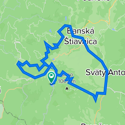
Dudince-Hontianske
A cycling route starting in Banská Štiavnica, Banskobystrický kraj, Slovak Republic.
Overview
About this route
BS-Hntianske Nemce-Dudince-Zemberovce-Hontianske Nemce-BS
- -:--
- Duration
- 104.8 km
- Distance
- 772 m
- Ascent
- 772 m
- Descent
- ---
- Avg. speed
- ---
- Avg. speed
Route quality
Waytypes & surfaces along the route
Waytypes
Busy road
79.6 km
(76 %)
Road
14.8 km
(14 %)
Surfaces
Paved
50.9 km
(49 %)
Unpaved
0.2 km
(<1 %)
Asphalt
50.2 km
(48 %)
Paved (undefined)
0.6 km
(<1 %)
Continue with Bikemap
Use, edit, or download this cycling route
You would like to ride Dudince-Hontianske or customize it for your own trip? Here is what you can do with this Bikemap route:
Free features
- Save this route as favorite or in collections
- Copy & plan your own version of this route
- Sync your route with Garmin or Wahoo
Premium features
Free trial for 3 days, or one-time payment. More about Bikemap Premium.
- Navigate this route on iOS & Android
- Export a GPX / KML file of this route
- Create your custom printout (try it for free)
- Download this route for offline navigation
Discover more Premium features.
Get Bikemap PremiumFrom our community
Other popular routes starting in Banská Štiavnica
- Č_studňa-Zlatý_Vrch-Hojan
- Distance
- 12.7 km
- Ascent
- 432 m
- Descent
- 432 m
- Location
- Banská Štiavnica, Banskobystrický kraj, Slovak Republic
- Banská Štiavnica - Kerling - Lukavica - Žarnovica
- Distance
- 17.2 km
- Ascent
- 588 m
- Descent
- 986 m
- Location
- Banská Štiavnica, Banskobystrický kraj, Slovak Republic
- BS- Červ.Studňa- Hodruša Hámre- Žarnovica
- Distance
- 19.5 km
- Ascent
- 697 m
- Descent
- 1,072 m
- Location
- Banská Štiavnica, Banskobystrický kraj, Slovak Republic
- BS- Štiavn.bane- Vindšacht. jazero (tajch)
- Distance
- 5.8 km
- Ascent
- 135 m
- Descent
- 52 m
- Location
- Banská Štiavnica, Banskobystrický kraj, Slovak Republic
- BS- Č.Studňa - Hodruš. tajch- Slamandra
- Distance
- 10.1 km
- Ascent
- 503 m
- Descent
- 511 m
- Location
- Banská Štiavnica, Banskobystrický kraj, Slovak Republic
- BS- Kalvária- Ban.Belá- Halč. jazero- s. Dubinky
- Distance
- 13.9 km
- Ascent
- 560 m
- Descent
- 457 m
- Location
- Banská Štiavnica, Banskobystrický kraj, Slovak Republic
- BS- Podhorie- Skl.Teplice - Hliník n.H.- D.Ždaňa
- Distance
- 22.3 km
- Ascent
- 365 m
- Descent
- 725 m
- Location
- Banská Štiavnica, Banskobystrický kraj, Slovak Republic
- BS- Červená Studňa- Vindišlajtňa- Vyhne
- Distance
- 13.1 km
- Ascent
- 440 m
- Descent
- 709 m
- Location
- Banská Štiavnica, Banskobystrický kraj, Slovak Republic
Open it in the app