

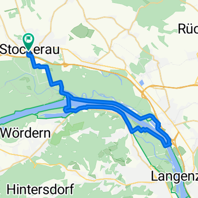
IVV_2017_Stockerau_81 km über Buschberg
A cycling route starting in Stockerau, Lower Austria, Austria.
Overview
About this route
- -:--
- Duration
- 81.5 km
- Distance
- 808 m
- Ascent
- 807 m
- Descent
- ---
- Avg. speed
- ---
- Max. altitude

Route quality
Waytypes & surfaces along the route
Waytypes
Road
26.1 km
(32 %)
Quiet road
10.6 km
(13 %)
Surfaces
Paved
52.1 km
(64 %)
Unpaved
9.8 km
(12 %)
Asphalt
52.1 km
(64 %)
Ground
3.3 km
(4 %)
Continue with Bikemap
Use, edit, or download this cycling route
You would like to ride IVV_2017_Stockerau_81 km über Buschberg or customize it for your own trip? Here is what you can do with this Bikemap route:
Free features
- Save this route as favorite or in collections
- Copy & plan your own version of this route
- Split it into stages to create a multi-day tour
- Sync your route with Garmin or Wahoo
Premium features
Free trial for 3 days, or one-time payment. More about Bikemap Premium.
- Navigate this route on iOS & Android
- Export a GPX / KML file of this route
- Create your custom printout (try it for free)
- Download this route for offline navigation
Discover more Premium features.
Get Bikemap PremiumFrom our community
Other popular routes starting in Stockerau
 Stage 2: Flo-rida’s Dorf to Schönberg
- Distance
- 49.8 km
- Ascent
- 194 m
- Descent
- 165 m
- Location
- Stockerau, Lower Austria, Austria
 getting lost around stockerau
- Distance
- 22.5 km
- Ascent
- 110 m
- Descent
- 113 m
- Location
- Stockerau, Lower Austria, Austria
 Stockerau - Buschberg
- Distance
- 76.6 km
- Ascent
- 671 m
- Descent
- 667 m
- Location
- Stockerau, Lower Austria, Austria
 Stockerau - Wien. Der Au-graveler am Wasser.
- Distance
- 34.9 km
- Ascent
- 125 m
- Descent
- 180 m
- Location
- Stockerau, Lower Austria, Austria
 Tumulus Radrunde
- Distance
- 71.3 km
- Ascent
- 456 m
- Descent
- 456 m
- Location
- Stockerau, Lower Austria, Austria
 Stockerau - Korneuburg und retour
- Distance
- 28.5 km
- Ascent
- 79 m
- Descent
- 78 m
- Location
- Stockerau, Lower Austria, Austria
 Stockerau - Sierndorf - Karnabrunn - Weinsteig - Mollmannstdorf - Leobendorf
- Distance
- 57 km
- Ascent
- 345 m
- Descent
- 345 m
- Location
- Stockerau, Lower Austria, Austria
 stockerau - Oberrußbach - Tulln 70km
- Distance
- 65.7 km
- Ascent
- 320 m
- Descent
- 313 m
- Location
- Stockerau, Lower Austria, Austria
Open it in the app