

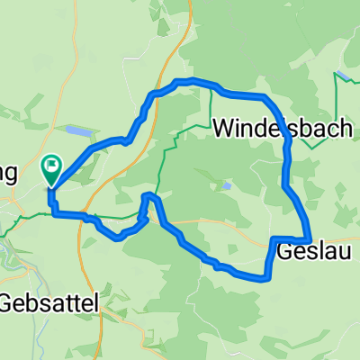
35_Rothenburg ob der Tauber – Leutershausen
A cycling route starting in Rothenburg upon Tauber, Bavaria, Germany.
Overview
About this route
Zum Quellgebiet der Altmühl
Charakter: Steiler und langer Anstieg ist kurz nach Rothenburg zu bewältigen, danach gibt es zwar immer wieder kleinere Anstiege, aber bis Leutershausen geht es dann überwiegend bergab. Die Strecke ist als „Altmühlweg“ ausgeschildert. Verkehr: Überwiegend wenig befahrene Nebenstraßen. Passender Reiseführer: KOMPASS 6404 Altmühlradweg, Karin Hornberg, ISBN 978-3-85026-408-2- -:--
- Duration
- 41.9 km
- Distance
- 171 m
- Ascent
- 168 m
- Descent
- ---
- Avg. speed
- ---
- Max. altitude
Route quality
Waytypes & surfaces along the route
Waytypes
Quiet road
18.4 km
(44 %)
Track
11.3 km
(27 %)
Surfaces
Paved
26.3 km
(63 %)
Unpaved
3.5 km
(8 %)
Asphalt
22.3 km
(53 %)
Gravel
3.5 km
(8 %)
Route highlights
Points of interest along the route

Point of interest after 1 km
Rothenburg ob der Tauber: Der Aufstieg über 220 Stufen belohnt mit einem Rundblick über die mittelalterliche Stadt, Rathaus, Marktplatz, Tel. (0)9861/404-177. Bild-/ Textquelle: KOMPASS Verlag

Point of interest after 1 km
Rothenburg ob der Tauber: Der Aufstieg über 220 Stufen belohnt mit einem Rundblick über die mittelalterliche Stadt, Rathaus, Marktplatz, Tel. (0)9861/404-177. Bild-/ Textquelle: KOMPASS Verlag

Point of interest after 19.1 km
Hornauer Weiher: Da man der Altmühl keine einzelne Quelle zuordnen kann, gilt das Quellgebiet des Hornauer Weihers als Urprung der Altmühl. Ab hier verläuft der Altmühl-Radweg immer in Nähe des Bachlaufs, der ab hier als Altmühl bezeichnet wird. Bild-/ Textquelle: KOMPASS Verlag
Continue with Bikemap
Use, edit, or download this cycling route
You would like to ride 35_Rothenburg ob der Tauber – Leutershausen or customize it for your own trip? Here is what you can do with this Bikemap route:
Free features
- Save this route as favorite or in collections
- Copy & plan your own version of this route
- Sync your route with Garmin or Wahoo
Premium features
Free trial for 3 days, or one-time payment. More about Bikemap Premium.
- Navigate this route on iOS & Android
- Export a GPX / KML file of this route
- Create your custom printout (try it for free)
- Download this route for offline navigation
Discover more Premium features.
Get Bikemap PremiumFrom our community
Other popular routes starting in Rothenburg upon Tauber
 35_Rothenburg ob der Tauber – Leutershausen
- Distance
- 41.9 km
- Ascent
- 171 m
- Descent
- 168 m
- Location
- Rothenburg upon Tauber, Bavaria, Germany
 Abendrunde über die Frankenhöhe
- Distance
- 18.2 km
- Ascent
- 146 m
- Descent
- 170 m
- Location
- Rothenburg upon Tauber, Bavaria, Germany
 Taubertal-Panorama
- Distance
- 52.4 km
- Ascent
- 733 m
- Descent
- 895 m
- Location
- Rothenburg upon Tauber, Bavaria, Germany
 Rothenburg to Bamberg
- Distance
- 120.8 km
- Ascent
- 98 m
- Descent
- 285 m
- Location
- Rothenburg upon Tauber, Bavaria, Germany
 Frankenhöhe
- Distance
- 25 km
- Ascent
- 219 m
- Descent
- 224 m
- Location
- Rothenburg upon Tauber, Bavaria, Germany
 Rund um Rothenburg
- Distance
- 23.1 km
- Ascent
- 463 m
- Descent
- 445 m
- Location
- Rothenburg upon Tauber, Bavaria, Germany
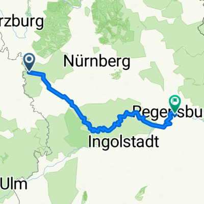 Rothenburg-Regensburg
- Distance
- 263.4 km
- Ascent
- 1,292 m
- Descent
- 1,373 m
- Location
- Rothenburg upon Tauber, Bavaria, Germany
 Altmühlradweg: Rothenburg-Kelheim
- Distance
- 244.8 km
- Ascent
- 316 m
- Descent
- 400 m
- Location
- Rothenburg upon Tauber, Bavaria, Germany
Open it in the app