

Tour de Italia 2017 dzień 2
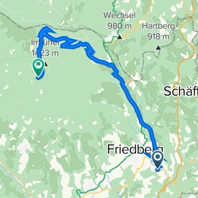
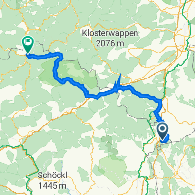
A cycling route starting in Pinggau, Styria, Austria.
Overview
About this route
Brandstatt – Pinggau (54) – Dechantskirchen – Limbach – Lafnitz – Grafendorf bei Hartberg – Neudorf – HARTBERG – Banki – Kaindorf – LangsrtraBe – Wallgraben – Kaibing – Hirnsdorf – Pischelsdorf in der Steinmark – Angerried – Prihnerried – Ilztal – Schattauberg – GLEISDORF (65) – Ludersdorf – Wilfersdorf – Brodersdrof – Brodingberg – Lembach – Kainbach bei Graz – Schillingsdorf – Ries – GRAZ (70) – Pirka – Lieboch – Schadendorf – Soding – Sankt Johann-Koppling – St.Johann ob Hohenburg – Krottendorf-Gaisfeld – Arnstein – Voitsberg – Rosental an der Kainach - Koflach – Hans Giegerl Siedlung (las)
- -:--
- Duration
- 133.1 km
- Distance
- 867 m
- Ascent
- 1,041 m
- Descent
- ---
- Avg. speed
- ---
- Max. altitude

Route quality
Waytypes & surfaces along the route
Waytypes
Busy road
63.5 km
(48 %)
Quiet road
23.3 km
(18 %)
Surfaces
Paved
91.3 km
(69 %)
Unpaved
4.1 km
(3 %)
Asphalt
84.6 km
(64 %)
Wood
3.6 km
(3 %)
Continue with Bikemap
Use, edit, or download this cycling route
You would like to ride Tour de Italia 2017 dzień 2 or customize it for your own trip? Here is what you can do with this Bikemap route:
Free features
- Save this route as favorite or in collections
- Copy & plan your own version of this route
- Split it into stages to create a multi-day tour
- Sync your route with Garmin or Wahoo
Premium features
Free trial for 3 days, or one-time payment. More about Bikemap Premium.
- Navigate this route on iOS & Android
- Export a GPX / KML file of this route
- Create your custom printout (try it for free)
- Download this route for offline navigation
Discover more Premium features.
Get Bikemap PremiumFrom our community
Other popular routes starting in Pinggau
 Sparbaregg
- Distance
- 8.6 km
- Ascent
- 292 m
- Descent
- 336 m
- Location
- Pinggau, Styria, Austria
 Haideggendorf 23 nach Haideggendorf 80
- Distance
- 0 km
- Ascent
- 0 m
- Descent
- 0 m
- Location
- Pinggau, Styria, Austria
 Haideggendorf trahütte vorauer schwaig
- Distance
- 22.9 km
- Ascent
- 1,051 m
- Descent
- 186 m
- Location
- Pinggau, Styria, Austria
 raststätte LoipersdPiorf - Pinkafeld - Vorau
- Distance
- 73.3 km
- Ascent
- 939 m
- Descent
- 935 m
- Location
- Pinggau, Styria, Austria
 Pinggau-Gillersdorf
- Distance
- 68.8 km
- Ascent
- 150 m
- Descent
- 412 m
- Location
- Pinggau, Styria, Austria
 Sparberegg 16 nach Grazer Straße 7, Mariazell
- Distance
- 117.5 km
- Ascent
- 3,101 m
- Descent
- 2,941 m
- Location
- Pinggau, Styria, Austria
 Sparberegg 16 nach Hauptplatz 12, Mariazell
- Distance
- 117.3 km
- Ascent
- 3,101 m
- Descent
- 2,928 m
- Location
- Pinggau, Styria, Austria
 Feistritzsattel
- Distance
- 114.3 km
- Ascent
- 1,833 m
- Descent
- 1,829 m
- Location
- Pinggau, Styria, Austria
Open it in the app