

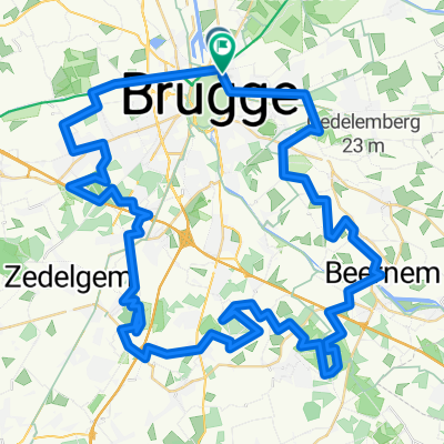
Hutsepotrit
A cycling route starting in Sint-Kruis, Flemish Region, Belgium.
Overview
About this route
Hutsepotrit 42 km
- -:--
- Duration
- 41.2 km
- Distance
- 52 m
- Ascent
- 53 m
- Descent
- ---
- Avg. speed
- ---
- Max. altitude

Route quality
Waytypes & surfaces along the route
Waytypes
Quiet road
18 km
(44 %)
Track
8.1 km
(20 %)
Surfaces
Paved
10.4 km
(25 %)
Unpaved
14 km
(34 %)
Asphalt
7.8 km
(19 %)
Gravel
7.8 km
(19 %)
Continue with Bikemap
Use, edit, or download this cycling route
You would like to ride Hutsepotrit or customize it for your own trip? Here is what you can do with this Bikemap route:
Free features
- Save this route as favorite or in collections
- Copy & plan your own version of this route
- Sync your route with Garmin or Wahoo
Premium features
Free trial for 3 days, or one-time payment. More about Bikemap Premium.
- Navigate this route on iOS & Android
- Export a GPX / KML file of this route
- Create your custom printout (try it for free)
- Download this route for offline navigation
Discover more Premium features.
Get Bikemap PremiumFrom our community
Other popular routes starting in Sint-Kruis
 Hutsepotrit
- Distance
- 41.2 km
- Ascent
- 52 m
- Descent
- 53 m
- Location
- Sint-Kruis, Flemish Region, Belgium
 RONDE BRUGGE - KNESSELARE - BRUGGE
- Distance
- 63.9 km
- Ascent
- 89 m
- Descent
- 90 m
- Location
- Sint-Kruis, Flemish Region, Belgium
 Zotte Rit
- Distance
- 76.1 km
- Ascent
- 114 m
- Descent
- 110 m
- Location
- Sint-Kruis, Flemish Region, Belgium
 Day 4
Day 4- Distance
- 73.4 km
- Ascent
- 21 m
- Descent
- 20 m
- Location
- Sint-Kruis, Flemish Region, Belgium
 Bruges Dame
- Distance
- 20.6 km
- Ascent
- 40 m
- Descent
- 37 m
- Location
- Sint-Kruis, Flemish Region, Belgium
 ZuienkerkeOostendeAartrijke N/O
- Distance
- 71.6 km
- Ascent
- 143 m
- Descent
- 143 m
- Location
- Sint-Kruis, Flemish Region, Belgium
 Testrit 1
- Distance
- 35.4 km
- Ascent
- 35 m
- Descent
- 32 m
- Location
- Sint-Kruis, Flemish Region, Belgium
 Boomkwekersstraat 38, Brugge nach Koninklijk Plein 7, De Haan
- Distance
- 20.2 km
- Ascent
- 20 m
- Descent
- 23 m
- Location
- Sint-Kruis, Flemish Region, Belgium
Open it in the app