

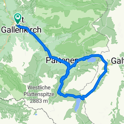
Bartholomäberg
A cycling route starting in Sankt Gallenkirch, Vorarlberg, Austria.
Overview
About this route
Kurzer aber steiler Aufstieg
- -:--
- Duration
- 35.5 km
- Distance
- 763 m
- Ascent
- 755 m
- Descent
- ---
- Avg. speed
- ---
- Max. altitude

Route quality
Waytypes & surfaces along the route
Waytypes
Quiet road
10.7 km
(30 %)
Path
8.5 km
(24 %)
Surfaces
Paved
34.1 km
(96 %)
Unpaved
1.1 km
(3 %)
Asphalt
34.1 km
(96 %)
Ground
1.1 km
(3 %)
Undefined
0.4 km
(1 %)
Continue with Bikemap
Use, edit, or download this cycling route
You would like to ride Bartholomäberg or customize it for your own trip? Here is what you can do with this Bikemap route:
Free features
- Save this route as favorite or in collections
- Copy & plan your own version of this route
- Sync your route with Garmin or Wahoo
Premium features
Free trial for 3 days, or one-time payment. More about Bikemap Premium.
- Navigate this route on iOS & Android
- Export a GPX / KML file of this route
- Create your custom printout (try it for free)
- Download this route for offline navigation
Discover more Premium features.
Get Bikemap PremiumFrom our community
Other popular routes starting in Sankt Gallenkirch
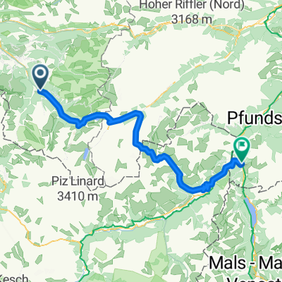 Von Bludenz bis Nauders
- Distance
- 76.9 km
- Ascent
- 3,739 m
- Descent
- 3,248 m
- Location
- Sankt Gallenkirch, Vorarlberg, Austria
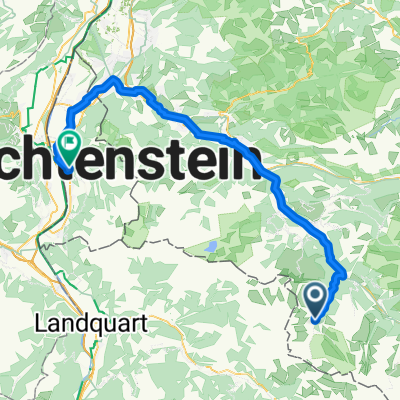
 Koopsstausee von St. Gallenkirch
- Distance
- 45.4 km
- Ascent
- 1,623 m
- Descent
- 1,620 m
- Location
- Sankt Gallenkirch, Vorarlberg, Austria
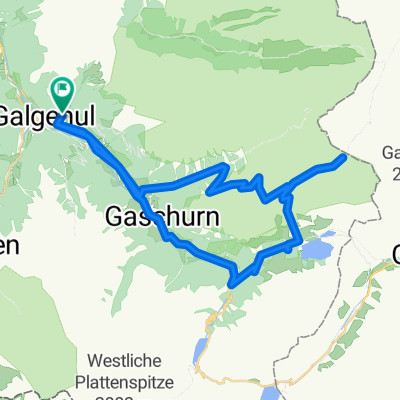
 Gargellen-Silvretta-Stausse-retour
- Distance
- 74 km
- Ascent
- 1,921 m
- Descent
- 1,921 m
- Location
- Sankt Gallenkirch, Vorarlberg, Austria
 MTB_Kops_Silvretta
- Distance
- 58.5 km
- Ascent
- 1,900 m
- Descent
- 1,899 m
- Location
- Sankt Gallenkirch, Vorarlberg, Austria
 Bartholomäberg
- Distance
- 35.5 km
- Ascent
- 763 m
- Descent
- 755 m
- Location
- Sankt Gallenkirch, Vorarlberg, Austria
 Gargellen Zentrum to Städtle
- Distance
- 68.6 km
- Ascent
- 567 m
- Descent
- 1,527 m
- Location
- Sankt Gallenkirch, Vorarlberg, Austria
 Rund ins Montafontal
- Distance
- 55 km
- Ascent
- 1,173 m
- Descent
- 1,172 m
- Location
- Sankt Gallenkirch, Vorarlberg, Austria
 Rund um die Valisera Talstation
- Distance
- 0.7 km
- Ascent
- 4 m
- Descent
- 0 m
- Location
- Sankt Gallenkirch, Vorarlberg, Austria
Open it in the app