

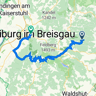
Döggingen-Behla-Sumpfohren
A cycling route starting in Eisenbach, Baden-Wurttemberg, Germany.
Overview
About this route
Unterbränd-Bittelbrunn-Döggingen-Behla-Sumpfohren-Hüfingen-Bräunlingen-Hubertshofen-Mistelbrunn approximately 48 km - 470 m elevation gain
- -:--
- Duration
- 48.9 km
- Distance
- 455 m
- Ascent
- 451 m
- Descent
- ---
- Avg. speed
- ---
- Max. altitude

Route quality
Waytypes & surfaces along the route
Waytypes
Track
20 km
(41 %)
Quiet road
17.1 km
(35 %)
Surfaces
Paved
23.5 km
(48 %)
Unpaved
13.7 km
(28 %)
Asphalt
19.6 km
(40 %)
Gravel
10.3 km
(21 %)
Continue with Bikemap
Use, edit, or download this cycling route
You would like to ride Döggingen-Behla-Sumpfohren or customize it for your own trip? Here is what you can do with this Bikemap route:
Free features
- Save this route as favorite or in collections
- Copy & plan your own version of this route
- Sync your route with Garmin or Wahoo
Premium features
Free trial for 3 days, or one-time payment. More about Bikemap Premium.
- Navigate this route on iOS & Android
- Export a GPX / KML file of this route
- Create your custom printout (try it for free)
- Download this route for offline navigation
Discover more Premium features.
Get Bikemap PremiumFrom our community
Other popular routes starting in Eisenbach
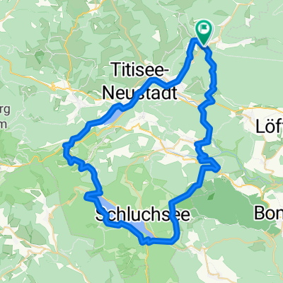 Titisee-Runde
- Distance
- 60.4 km
- Ascent
- 774 m
- Descent
- 779 m
- Location
- Eisenbach, Baden-Wurttemberg, Germany
 Schwarzwald Elsass Tag3
- Distance
- 103.3 km
- Ascent
- 1,839 m
- Descent
- 2,536 m
- Location
- Eisenbach, Baden-Wurttemberg, Germany
 24.05.2022 Tourplanung1- 2.Gruppe
- Distance
- 41.5 km
- Ascent
- 732 m
- Descent
- 742 m
- Location
- Eisenbach, Baden-Wurttemberg, Germany
 Donau-Radweg komplett
- Distance
- 2,664.1 km
- Ascent
- 8,923 m
- Descent
- 9,925 m
- Location
- Eisenbach, Baden-Wurttemberg, Germany
 WasserWeltenSteig 3. Etappe Hammereisenbach - Unterbränd / Kirnbergsee
- Distance
- 11.5 km
- Ascent
- 253 m
- Descent
- 211 m
- Location
- Eisenbach, Baden-Wurttemberg, Germany
 Teilstrecke1 Donau
- Distance
- 3,003.6 km
- Ascent
- 655 m
- Descent
- 1,646 m
- Location
- Eisenbach, Baden-Wurttemberg, Germany
 Döggingen-Behla-Sumpfohren
- Distance
- 48.9 km
- Ascent
- 455 m
- Descent
- 451 m
- Location
- Eisenbach, Baden-Wurttemberg, Germany
 X07 Hammereisenbach Donaueschingen 21 km
- Distance
- 21.3 km
- Ascent
- 64 m
- Descent
- 142 m
- Location
- Eisenbach, Baden-Wurttemberg, Germany
Open it in the app